IMAGES TAKEN NEAR TO
UB8 1FN
Introduction
This page details the photographs taken nearby to UB8 1FN by members of the Geograph project.
The Geograph project started in 2005 with the aim of publishing, organising and preserving representative images for every square kilometre of Great Britain, Ireland and the Isle of Man.

There are currently over 7.5m images from over14,400 individuals and you can help contribute to the project by visiting https://www.geograph.org.uk
Image Map
Images are licensed for reuse under creativecommons.org/licenses/by-sa/2.0
Notes
- Clicking on the map will re-center to the selected point.
- The higher the marker number, the further away the image location is from the centre of the postcode.
Image Listing (83 Images Found)
Images are licensed for reuse under creativecommons.org/licenses/by-sa/2.0
Image
Details
Distance
2
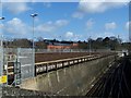
Uxbridge Belmont Road Underground station (site), Greater London
Opened in 1904 by the Metropolitan Railway as the terminus of the line from Harrow, this station closed in 1938 when it was replaced by the current Underground station, which is a terminus for the Metropolitan and Piccadilly lines.
View north east towards the former forecourt - the building was situated between the trolley park and the main building, with the running lines immediately behind it. The buffer stops would have been extreme left on this image.
Like 55% of the Underground network, this part is actually overground.
Image: © Nigel Thompson
Taken: 31 Jul 2018
0.11 miles
4
Sidings at Uxbridge Underground Station
You can see Sainsbury's in the background, which now stands on the former Underground station.
Image: © Rob Emms
Taken: 9 Mar 2007
0.16 miles
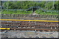
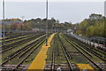
8
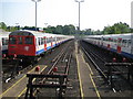
Uxbridge: Metropolitan Line sidings
Viewed from York Road, these sidings are used to stable trains overnight, or, in this case on a Sunday, when the normal full weekday complement of trains is not used. This location was the site of the goods sidings for the original London Underground station in Uxbridge which operated from 1904 to 1938.
Image: © Nigel Cox
Taken: 11 May 2008
0.16 miles
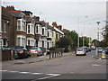
9
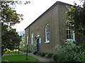
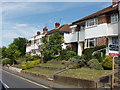
Uxbridge: Quakers' Meeting House
The Religious Society of Friends, known as the Quakers, have been worshipping in Uxbridge since 1658 and in this building since 1818. The Meeting House is on Belmont Road at its junction with York Road. Meetings are held every Sunday at 10.30 am.
Image: © Nigel Cox
Taken: 11 May 2008
0.17 miles