IMAGES TAKEN NEAR TO
Mulberry Crescent, WEST DRAYTON, UB7 9AH
Introduction
This page details the photographs taken nearby to Mulberry Crescent, UB7 9AH by members of the Geograph project.
The Geograph project started in 2005 with the aim of publishing, organising and preserving representative images for every square kilometre of Great Britain, Ireland and the Isle of Man.

There are currently over 7.5m images from over14,400 individuals and you can help contribute to the project by visiting https://www.geograph.org.uk
Image Map
Images are licensed for reuse under creativecommons.org/licenses/by-sa/2.0
Notes
- Clicking on the map will re-center to the selected point.
- The higher the marker number, the further away the image location is from the centre of the postcode.
Image Listing (55 Images Found)
Images are licensed for reuse under creativecommons.org/licenses/by-sa/2.0
Image
Details
Distance
1
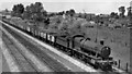
Up freight west of Hayes & Harlington
View westward near Dawley Box, towards West Drayton, Reading and the West; ex-GW Paddington - Reading etc. main line. This is close to where the Heathrow Express line (opened 1/98, fully 23/6/98) now branches off to the Airport from the main line. The Class H freight is headed by '2883' 2-8-0 No. 3824 (built 9/40).
Image: © Ben Brooksbank
Taken: 8 Jun 1962
0.08 miles
2
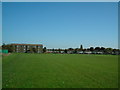
Bourne Farm Field
Looking east. New buildings being built on Government land behind green fence on left.
Image: © Ray Stanton
Taken: 27 Oct 2005
0.09 miles
3
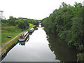
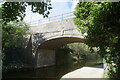
Grand Union Canal
Looking in the direction of Hayes from the Iron Bridge Road bridge with Stockley Park to the left. The low bridge in the distance is for the Old Stockley Road crossing of the canal. The high bridge in the distance is for the A408 Stockley Road crossing.
Image: © Nigel Cox
Taken: 14 Jun 2006
0.10 miles
4
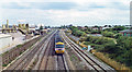
Paddington - Reading main line at Dawley, near site of Airport Junction, 1994
View eastward from A408 Stockley Road bridge, towards Hayes & Harlington station (out of sight) and London Paddington: ex-GWR main line to Bristol etc. via Reading. The grade-separated junction of the Heathrow Airport branch, which was opened in 1998, with electrification of the lines from Paddington, is not yet in existence in 1994. An Up IC125 express is here rushing away towards Paddington.
Image: © Ben Brooksbank
Taken: 29 Aug 1994
0.12 miles
5
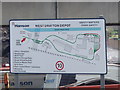
Map of Hanson West Drayton depot
This map at the depot entrance shows that it has rail and canal discharge, Benninghoven B320 asphalt tower, cement premix, and storage bays.
Image: © David Hawgood
Taken: 18 May 2008
0.12 miles
6

Orange Way after Wiltshire (510)
Swans, reflecting, near Stockley Bridge.
Image: © Shazz
Taken: 12 Sep 2013
0.12 miles
7
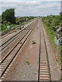
Main line railway from Stockley Road
Lines used by Heathrow Express, the main line from Paddington to the west, and will also be part of Crossrail. The photo shows the railway as far as Horton Bridge.
Image: © David Hawgood
Taken: 18 May 2008
0.12 miles
10
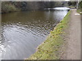
The Grand Union Canal at Stockley Park
This section of the Grand Union Canal from the River Thames at Brentford was opened in 1794. It was the first section of what was originally called the Grand Junction Canal. Its purpose was to provide a new, shorter and quicker transport route between London and Birmingham by connecting with a network of canals at Braunston near Daventry. When the canal reached Braunston in 1805 it cut 60 miles off the shortest alternative route.
The London LOOP passes through Stockley Country Park and Stockley Business Park to the north of here, leaving the towpath about half a mile behind where I am standing and rejoining it about half a mile ahead at West Drayton.
Image: © Marathon
Taken: 14 Mar 2018
0.12 miles