IMAGES TAKEN NEAR TO
Lowdell Close, WEST DRAYTON, UB7 8BB
Introduction
This page details the photographs taken nearby to Lowdell Close, UB7 8BB by members of the Geograph project.
The Geograph project started in 2005 with the aim of publishing, organising and preserving representative images for every square kilometre of Great Britain, Ireland and the Isle of Man.

There are currently over 7.5m images from over14,400 individuals and you can help contribute to the project by visiting https://www.geograph.org.uk
Image Map
Images are licensed for reuse under creativecommons.org/licenses/by-sa/2.0
Notes
- Clicking on the map will re-center to the selected point.
- The higher the marker number, the further away the image location is from the centre of the postcode.
Image Listing (11 Images Found)
Images are licensed for reuse under creativecommons.org/licenses/by-sa/2.0
Image
Details
Distance
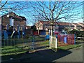
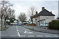
2
Barr Lodge sheltered housing
On Bond Close, which is all sheltered housing - the building with the porch appears to be the management centre/
Image: © Robin Webster
Taken: 18 Jan 2015
0.12 miles
3

Philpot's Farm Open Space
Philpot's Farm Open Space was once part of a working farm and passed to the London Borough of Hillingdon in the 1970s. It is a wet meadow and originally the site would have been marsh and damp meadow used for grazing sheep and cattle.
The River Pinn runs along the eastern edge of the open space. The Pinn is one of the feeders of the River Colne. It is nearly twelve miles long and was formally known as the Ruislip Brook. It rises on Harrow Weald Common and eventually joins the Frays River at Yiewsley. The Frays River then joins the Colne to the south-west of Drayton Mill and eventually reaches the Thames at Staines.
The Celandine route passes through Philpot's Farm Open Space. This is a 12 mile walk which follows the River Pinn from Pinner to the Grand Union Canal at Cowley - see https://archive.hillingdon.gov.uk/article/8718/Celandine-walks The houses ahead are on Heather Lane.
Image: © Marathon
Taken: 8 Aug 2018
0.15 miles
4
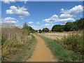
Path on Philpot's Farm Open Space
Philpot's Farm Open Space was once part of a working farm and passed to the London Borough of Hillingdon in the 1970s. It is a wet meadow and originally the site would have been marsh and damp meadow used for grazing sheep and cattle.
The River Pinn runs along the eastern edge of the open space. The Pinn is one of the feeders of the River Colne. It is nearly twelve miles long and was formally known as the Ruislip Brook. It rises on Harrow Weald Common and eventually joins the Frays River at Yiewsley. The Frays River then joins the Colne to the south-west of Drayton Mill and eventually reaches the Thames at Staines.
The Celandine route passes through Philpot's Farm Open Space. This is a 12 mile walk which follows the River Pinn from Pinner to the Grand Union Canal at Cowley - see https://archive.hillingdon.gov.uk/article/8718/Celandine-walks The houses ahead are on Heather Lane.
Image: © Marathon
Taken: 8 Aug 2018
0.17 miles
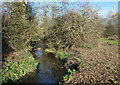
5

Path through Philpot's Farm
Philpot's Farm was a farm up until the 1970's. Now, with the name retained, it is run by Hillingdon Council as a nature reserve and park.
The site is made up of mixed grass and woodland, with the River Pinn flowing southwards through it.
Image: © Des Blenkinsopp
Taken: 28 Nov 2017
0.18 miles
6
Philpot's Farm Open Space
Philpot's Farm Open Space was once part of a working farm and passed to the London Borough of Hillingdon in the 1970s. It is a wet meadow and originally the site would have been marsh and damp meadow used for grazing sheep and cattle.
The River Pinn runs along the eastern edge of the open space. The Pinn is one of the feeders of the River Colne. It is nearly twelve miles long and was formally known as the Ruislip Brook. It rises on Harrow Weald Common and eventually joins the Frays River at Yiewsley. The Frays River then joins the Colne to the south-west of Drayton Mill and eventually reaches the Thames at Staines.
The Celandine route passes through Philpot's Farm Open Space. This is a 12 mile walk which follows the River Pinn from Pinner to the Grand Union Canal at Cowley - see https://archive.hillingdon.gov.uk/article/8718/Celandine-walks The houses ahead are on Heather Lane.
Image: © Marathon
Taken: 8 Aug 2018
0.18 miles
7
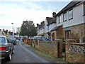
Houses on Pear Tree Avenue, Yiewsley
Where parking partly on the pavement is encouraged.
Image: © Robin Webster
Taken: 18 Jan 2015
0.20 miles
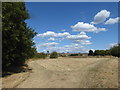
9
River Pinn at Philpott's Farm
Philpot's Farm was a farm up until the 1970's. Now, with the name retained, it is run by Hillingdon Council as a nature reserve and park.
The Pinn is a tributary of the Colne. From its source near Harrow, it follows a southerly course, through Pinner amongst other places before joining Fray's River, part of the Colne, at Yiewsley.
Image: © Des Blenkinsopp
Taken: 28 Nov 2017
0.23 miles
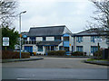
10
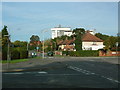
Apple Tree Avenue/Violet Avenue junction
Hillingdon Hospital behind
Image: © Ray Stanton
Taken: 7 Nov 2005
0.23 miles