IMAGES TAKEN NEAR TO
Verulam Road, GREENFORD, UB6 9RH
Introduction
This page details the photographs taken nearby to Verulam Road, UB6 9RH by members of the Geograph project.
The Geograph project started in 2005 with the aim of publishing, organising and preserving representative images for every square kilometre of Great Britain, Ireland and the Isle of Man.

There are currently over 7.5m images from over14,400 individuals and you can help contribute to the project by visiting https://www.geograph.org.uk
Image Map
Images are licensed for reuse under creativecommons.org/licenses/by-sa/2.0
Notes
- Clicking on the map will re-center to the selected point.
- The higher the marker number, the further away the image location is from the centre of the postcode.
Image Listing (19 Images Found)
Images are licensed for reuse under creativecommons.org/licenses/by-sa/2.0
Image
Details
Distance
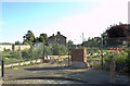
2
Allotments, Ruislip Road, Greenford (1)
Main entrance in Ruislip Road. Demolished week beginning 18 May 2009.
Image: © MrC
Taken: 11 Apr 2009
0.06 miles
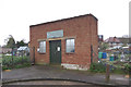
3
Allotments, Ruislip Road, Greenford (2)
The former entrance to the allotments, after demolition. See also Image
Image: © MrC
Taken: 11 Aug 2009
0.06 miles


9
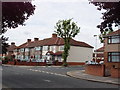
Houses in Lyndhurst Road, Greenford
A quiet residential street, with houses built in the early 1930s.
Image: © MrC
Taken: 23 Sep 2008
0.18 miles
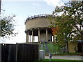
10
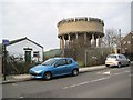
Southall: Allenby Road Water Tower
The water tower is contemporary with the inter-war housing estates around it. Before the houses were built Allenby Road was known as Muddy Lane. As ever with water towers these days this one is festooned with the usual array of communications aerials.
The hut on the left is a Scout Hall.
Image: © Nigel Cox
Taken: 13 Jan 2013
0.19 miles