IMAGES TAKEN NEAR TO
Dehavilland Close, NORTHOLT, UB5 6RU
Introduction
This page details the photographs taken nearby to Dehavilland Close, UB5 6RU by members of the Geograph project.
The Geograph project started in 2005 with the aim of publishing, organising and preserving representative images for every square kilometre of Great Britain, Ireland and the Isle of Man.

There are currently over 7.5m images from over14,400 individuals and you can help contribute to the project by visiting https://www.geograph.org.uk
Image Map
Images are licensed for reuse under creativecommons.org/licenses/by-sa/2.0
Notes
- Clicking on the map will re-center to the selected point.
- The higher the marker number, the further away the image location is from the centre of the postcode.
Image Listing (5 Images Found)
Images are licensed for reuse under creativecommons.org/licenses/by-sa/2.0
Image
Details
Distance
1
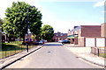
London Borough of Ealing : The Parkway (A312)
Entering the London Borough of Ealing in Northolt on the A312.
Image: © Lewis Clarke
Taken: 23 Mar 2018
0.07 miles
2
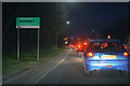
London Borough of Ealing : The Parkway (A312)
A sign warns of delays on the A40.
Image: © Lewis Clarke
Taken: 23 Mar 2018
0.09 miles
3
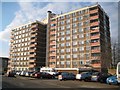
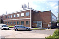
Northolt: Woburn Tower
Woburn Tower is a ten storey residential block of flats on Broomcroft Avenue, although this is the view from the parallel Radcliffe Way.
Image: © Nigel Cox
Taken: 13 Jan 2013
0.15 miles