IMAGES TAKEN NEAR TO
Ashford Avenue, HAYES, UB4 0NA
Introduction
This page details the photographs taken nearby to Ashford Avenue, UB4 0NA by members of the Geograph project.
The Geograph project started in 2005 with the aim of publishing, organising and preserving representative images for every square kilometre of Great Britain, Ireland and the Isle of Man.

There are currently over 7.5m images from over14,400 individuals and you can help contribute to the project by visiting https://www.geograph.org.uk
Image Map
Images are licensed for reuse under creativecommons.org/licenses/by-sa/2.0
Notes
- Clicking on the map will re-center to the selected point.
- The higher the marker number, the further away the image location is from the centre of the postcode.
Image Listing (58 Images Found)
Images are licensed for reuse under creativecommons.org/licenses/by-sa/2.0
Image
Details
Distance
6
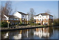
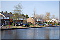
Grand Union Canal (Paddington Arm): Reach in Southall
The photographer writes reach in Southall, but the canal here forms the administrative boundary between the London Borough of Hillingdon to the left and the London Borough of Ealing to the right. The residential properties on the far side of the canal are on Tollgate Drive in Hayes.
Image: © Nigel Cox
Taken: 13 Jan 2013
0.17 miles
7
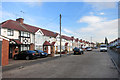
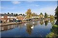
Housing Estate, Southall
A new housing complex on the banks of the Grand Union Canal.
Image: © Phillip Perry
Taken: 7 Jun 2008
0.17 miles
8
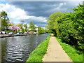
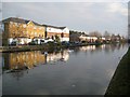
The Paddington Arm of the Grand Union Canal at Southall
The Paddington Arm of the then Grand Junction Canal was opened in 1801 from Bull's Bridge near Southall to Paddington Basin. The canals were initially a success, particularly for transporting coal, building materials and other bulky loads, but the rise of the railways not long after the canals were built substantially reduced their importance. Now they are primarily a leisure facility. The Paddington Arm was one of the last to see the old-fashioned style of regular commercial traffic of paired narrow boats carrying the traditional materials such as coal, oils, and tar. The Paddington Arm now sees regular commercial traffic, usually in the form of aggregates.
The new houses on the opposite side are along Tollgate Drive. Until recently there were factories here.
Image: © Marathon
Taken: 25 Apr 2018
0.18 miles
9
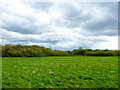
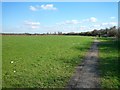
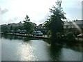
Brookside Open Space
The brook in question is the Yeading Brook which is a tributary of the River Crane. The Dog Rose Ramble and the Hillingdon Trail pass through Brookside Open Space, just after crossing the Paddington Arm of the Grand Union Canal at Spikes Bridge. See http://www.bertuchi.co.uk/dogroseramble.php for more about the Dog Rose Ramble. There was an interesting cloud formation when I took this photograph on a day of sunshine and showers.
Image: © Marathon
Taken: 25 Apr 2018
0.18 miles