IMAGES TAKEN NEAR TO
Pendell Avenue, HAYES, UB3 5HH
Introduction
This page details the photographs taken nearby to Pendell Avenue, UB3 5HH by members of the Geograph project.
The Geograph project started in 2005 with the aim of publishing, organising and preserving representative images for every square kilometre of Great Britain, Ireland and the Isle of Man.

There are currently over 7.5m images from over14,400 individuals and you can help contribute to the project by visiting https://www.geograph.org.uk
Image Map
Images are licensed for reuse under creativecommons.org/licenses/by-sa/2.0
Notes
- Clicking on the map will re-center to the selected point.
- The higher the marker number, the further away the image location is from the centre of the postcode.
Image Listing (58 Images Found)
Images are licensed for reuse under creativecommons.org/licenses/by-sa/2.0
Image
Details
Distance
1
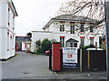
The White House, Cranford Lane
This was known as the "Red House" on earlier maps. It was once the home of the Thomas Moreton Fitzhardinge Berkeley (1796-1882), the de jure 6th Earl of Berkely, who is buried at St Dunstan's, Cranford (TQ1078).
Image: © MrC
Taken: Unknown
0.05 miles
3
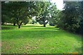
Cranford Park Open Space
Viewed looking south from the Cranford Lane entrance towards the A4 road.
Image: © Nigel Cox
Taken: 6 Sep 2005
0.13 miles
5
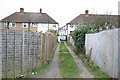
Back o' Langley Crescent
Alley to Langley Crescent
Image: © Richard Croft
Taken: 13 Mar 2008
0.14 miles
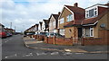
6
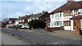
Houses in Craneswater
Alongside the A4.
Image: © David Martin
Taken: 17 Feb 2020
0.14 miles
9
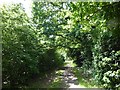
Woodland path in Cranford Countryside Park
Cranford House was the seat of the Berkeleys up until the end of the 19th century. The early Georgian mansion was demolished in 1945 at the end of the Second World War which was about the time that the park came into public ownership. The 18th century stable and barn block survive, as do the cellars of the old house, and the old parish church of Cranford. St Dunstan's Church dates from the 15th and 17th centuries and is approached through a lych gate by the stable block. There is also a ha-ha, a large walled garden, the site of an ice house, and some ancient woodland.
This woodland is along the western edge of the park. A feeder stream of the River Crane is longside to the right and Cranford Lane is a short distance ahead..
Image: © Marathon
Taken: 6 Jun 2018
0.15 miles
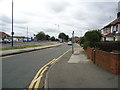
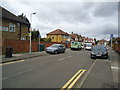
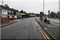
10
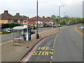
Eastbound A4, Craneswater bus stop
Craneswater is the parallel residential road.
Image: © Robin Webster
Taken: 22 Apr 2018
0.15 miles