IMAGES TAKEN NEAR TO
Maxwell Close, HAYES, UB3 3DX
Introduction
This page details the photographs taken nearby to Maxwell Close, UB3 3DX by members of the Geograph project.
The Geograph project started in 2005 with the aim of publishing, organising and preserving representative images for every square kilometre of Great Britain, Ireland and the Isle of Man.

There are currently over 7.5m images from over14,400 individuals and you can help contribute to the project by visiting https://www.geograph.org.uk
Image Map
Images are licensed for reuse under creativecommons.org/licenses/by-sa/2.0
Notes
- Clicking on the map will re-center to the selected point.
- The higher the marker number, the further away the image location is from the centre of the postcode.
Image Listing (13 Images Found)
Images are licensed for reuse under creativecommons.org/licenses/by-sa/2.0
Image
Details
Distance
1
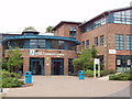
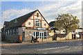
Hayes Community Campus
These new buildings of Uxbridge College include provision for training in dance, hairdressing, and leisure industry courses. Performing arts studios are adjacent.
Image: © David Hawgood
Taken: 1 Jul 2005
0.03 miles
2
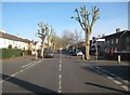
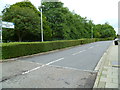
Hayes: Central Avenue
This is Central Avenue, the main spine road through this area of Hayes that was mainly developed residentially between the two World Wars. This view is at the junction with Orchard Road and features some recently severely lopped street trees!
Image: © Nigel Cox
Taken: 11 Jan 2015
0.12 miles
3
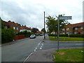
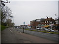
Looking west at the junction of Hesa and Wesley Roads
Image: © Shazz
Taken: 12 Sep 2013
0.13 miles
4
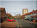
Hayes - Wesley Road
Terrace housing and tower block
Image: © James Emmans
Taken: 20 Nov 2019
0.17 miles
5
Looking east along St Christopher Drive from Coldharbour Lane
Image: © Shazz
Taken: 12 Sep 2013
0.18 miles
6
Uxbridge Road, Hayes
The bingo hall pictured in the First Geograph can be seen over the road
Image: © Ray Stanton
Taken: 22 Apr 2007
0.19 miles
7
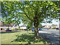
Green space next to Coldharbour Lane
This small green space is a semi-circle between Coldharbour Lane, which is the main road to the right, and Eastholme.
Image: © Marathon
Taken: 23 May 2018
0.19 miles
8
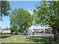
Green space next to Coldharbour Lane
This small green space is a semi-circle between Coldharbour Lane, which is the main road to the right, and Eastholme.
Image: © Marathon
Taken: 23 May 2018
0.20 miles
10
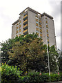
London Borough of Hillingdon : Harding House
A tower block seen from Uxbridge Road.
Image: © Lewis Clarke
Taken: 18 Jul 2019
0.23 miles