IMAGES TAKEN NEAR TO
Central Avenue, HAYES, UB3 2BS
Introduction
This page details the photographs taken nearby to Central Avenue, UB3 2BS by members of the Geograph project.
The Geograph project started in 2005 with the aim of publishing, organising and preserving representative images for every square kilometre of Great Britain, Ireland and the Isle of Man.

There are currently over 7.5m images from over14,400 individuals and you can help contribute to the project by visiting https://www.geograph.org.uk
Image Map
Images are licensed for reuse under creativecommons.org/licenses/by-sa/2.0
Notes
- Clicking on the map will re-center to the selected point.
- The higher the marker number, the further away the image location is from the centre of the postcode.
Image Listing (15 Images Found)
Images are licensed for reuse under creativecommons.org/licenses/by-sa/2.0
Image
Details
Distance
1
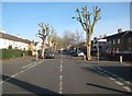
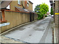
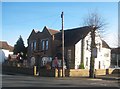
Hayes: Central Avenue
This is Central Avenue, the main spine road through this area of Hayes that was mainly developed residentially between the two World Wars. This view is at the junction with Orchard Road and features some recently severely lopped street trees!
Image: © Nigel Cox
Taken: 11 Jan 2015
0.03 miles
2
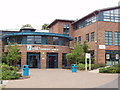
Hayes Community Campus
These new buildings of Uxbridge College include provision for training in dance, hairdressing, and leisure industry courses. Performing arts studios are adjacent.
Image: © David Hawgood
Taken: 1 Jul 2005
0.13 miles
3
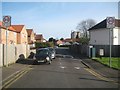
Hayes: Rectory Road
This road was probably named after the long lost Rectory Farm rather than the Rectory itself which was on Church Road some distance away.
Image: © Nigel Cox
Taken: 11 Jan 2015
0.19 miles
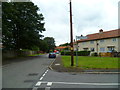
4
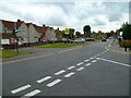
Looking west on Hemmen Lane from Rectory Road
Image: © Shazz
Taken: 12 Sep 2013
0.19 miles
6
Hotel on Church Road
The plaque commemorates George Orwell.
Image: © Shazz
Taken: 12 Sep 2013
0.20 miles
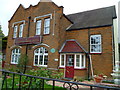
7
Fountain House Hotel, Church Road, Hayes
Now a hotel, this used to be a private school where the writer George Orwell (real name Eric Arthur Blair) taught for a time in the early 1930s. The school was known as 'The Hawthorns' and was a private school for boys. It was run simply as a business by its owner and Orwell's opinion of it was very low. He referred to it as 'a dirty swindle' in private correspondence. His view of Hayes itself was not much better. In the same letter he described Hayes as
'one of the most godforsaken places I have ever struck. The population seems to be entirely made up of clerks who frequent tin-roofed chapels on Sundays & for the rest bolt themselves within doors.'*
*'George Orwell' by Gordon Bowker, Little, Brown 2003.
Image: © Brian Robert Marshall
Taken: Unknown
0.21 miles
8
Looking west at the junction of Hesa and Manor Roads
Image: © Shazz
Taken: 12 Sep 2013
0.21 miles
9
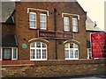
Hayes: Fountain House Hotel
Please see Brian's Image for a description of how George Orwell is linked to this building and his (Orwell's not Brian's) reputed opinions of the denizens of Hayes! The green plaque appears to have moved across the front of the building since 2004, possibly to a more prominent location on the corner while the owners have added their own sign.
Image: © Nigel Cox
Taken: 11 Jan 2015
0.21 miles
10
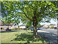
Green space next to Coldharbour Lane
This small green space is a semi-circle between Coldharbour Lane, which is the main road to the right, and Eastholme.
Image: © Marathon
Taken: 23 May 2018
0.22 miles