IMAGES TAKEN NEAR TO
Warnford Industrial Estate, Clayton Road, HAYES, UB3 1BQ
Introduction
This page details the photographs taken nearby to Warnford Industrial Estate, Clayton Road, UB3 1BQ by members of the Geograph project.
The Geograph project started in 2005 with the aim of publishing, organising and preserving representative images for every square kilometre of Great Britain, Ireland and the Isle of Man.

There are currently over 7.5m images from over14,400 individuals and you can help contribute to the project by visiting https://www.geograph.org.uk
Image Map
Images are licensed for reuse under creativecommons.org/licenses/by-sa/2.0
Notes
- Clicking on the map will re-center to the selected point.
- The higher the marker number, the further away the image location is from the centre of the postcode.
Image Listing (49 Images Found)
Images are licensed for reuse under creativecommons.org/licenses/by-sa/2.0
Image
Details
Distance
3
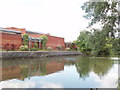
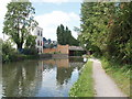
EMI Music Archive, Hayes
View across the Grand Union Canal of EMI Records' worldwide music archive. This purpose built facility was constructed in the 1990s alongside EMI's Central Research Laboratories (CRL) which was built ten years earlier. The CRL building has now been demolished but the Archive building remains.
The Archive houses pretty much the entire output of EMI. The one notable exception is the master tapes of The Beatles recordings. They are housed at Abbey Road studios in London.
Image: © David Hawgood
Taken: 18 May 2008
0.05 miles
4
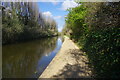
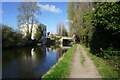
Grand Union Canal west of bridge 199
Warnford Industrial Estate is hidden behind the trees on the left.
Image: © David Hawgood
Taken: 18 May 2008
0.06 miles
5
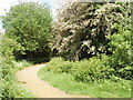
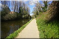
Path into Stockley Country Park
This is a few yards from the Grand Union Canal. Stockley Park has been developed as an area of office buildings close to Heathrow Airport. The northern 274 acres have been laid out as parkland for recreational use, with 11 lakes and nearly 200,000 trees and shrubs. The blossom in the photo is hawthorn.
Image: © David Hawgood
Taken: 18 May 2008
0.09 miles
6
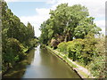
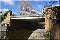
Grand Union Canal bridge 199 - Printinghouse Lane
Houses were built along Printinghouse Lane - then called Workhouse Lane - in the early years of the 20th Century when factories were built between the canal and railway. See Victoria County History extract http://www.british-history.ac.uk/report.aspx?compid=22391 . A sign on the bridge says it is Anchor Bridge, originally built in 1794, rebuilt in 1992 by Costain, designed by Hillingdon Engineering Consultancy.
Image: © David Hawgood
Taken: 18 May 2008
0.09 miles
9
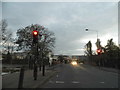
Printing House Lane crossing the Grand Union Canal
The bridge was not a single lane but has been deliberately reduced to one, requiring traffic lights to sort the vehicles to pass alternately. Maybe the bridge was weak but it appears to be fairly new so that's not very likely. Hayes gets extremely busy during the week and I dread the sort of tailbacks this produces every rush hour and school time.
Image: © David Howard
Taken: 9 Nov 2014
0.10 miles
10
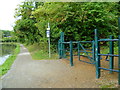
Orange Way after Wiltshire (521)
A path goes north here. The signpost says "Trails of Discovery".
Image: © Shazz
Taken: 12 Sep 2013
0.10 miles