IMAGES TAKEN NEAR TO
McNair Road, SOUTHALL, UB2 4XG
Introduction
This page details the photographs taken nearby to McNair Road, UB2 4XG by members of the Geograph project.
The Geograph project started in 2005 with the aim of publishing, organising and preserving representative images for every square kilometre of Great Britain, Ireland and the Isle of Man.

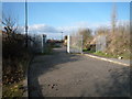
There are currently over 7.5m images from over14,400 individuals and you can help contribute to the project by visiting https://www.geograph.org.uk
Image Map
Images are licensed for reuse under creativecommons.org/licenses/by-sa/2.0
Notes
- Clicking on the map will re-center to the selected point.
- The higher the marker number, the further away the image location is from the centre of the postcode.
Image Listing (150 Images Found)
Images are licensed for reuse under creativecommons.org/licenses/by-sa/2.0
Image
Details
Distance
2
Southall from the air
The railway east of Southall station and the western end of the Great Western Industrial Estate.
Image: © Mike Pennington
Taken: 31 Aug 2018
0.02 miles
3
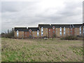
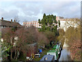
Toplocks Estate
The rear of housing at the end of McNair Road. This was originally industrial land.
Image: © Alan Murray-Rust
Taken: 9 Jan 2012
0.05 miles
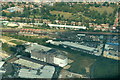
4
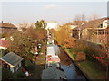
Maypole Dock
Branch of the Grand Union Canal to the Maypole Dairy Co margarine factory, now used as private moorings.
Image: © Alan Murray-Rust
Taken: 9 Jan 2012
0.07 miles
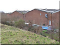
5

End of the line
Toplocks Estate bus terminus. This and the Havelock Estate are a bit cut off from the main road network by the canal and industry, and are served by a local route with small buses.
Image: © Alan Murray-Rust
Taken: 9 Jan 2012
0.07 miles
7
Canal branch to Southall for margarine factory
This branch off the Grand Union Canal was installed to serve the large Otto Monsted margarine factory, the Maypole Dairy, in what was then Margarine Road, now Bridge Road. The factory opened in 1893 and later became part of Unilever. See Victoria County History for Middlesex http://www.british-history.ac.uk/report.aspx?compid=22402 .
Image: © David Hawgood
Taken: 29 Dec 2008
0.09 miles
8
Maypole Dock
Looking north from Havelock Road bridge, with the former Quaker Oats factory in the distance. The dock - actually a half-mile length of canal - is now used for private moorings.
Image: © Alan Murray-Rust
Taken: 9 Jan 2012
0.09 miles
9
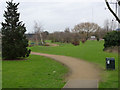
Glade Lane Canalside Park
Recently developed on the site of the Borough of Ealing's nursery for bedding plants, etc.
Image: © Alan Murray-Rust
Taken: 9 Jan 2012
0.10 miles
10
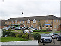
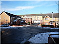
Toplocks Estate
Recent housing development on former industrial land. The estate takes its name from the adjacent Norwood Top Lock on the Grand Union Canal. This block contains the local shop and medical centre.
Image: © Alan Murray-Rust
Taken: 9 Jan 2012
0.10 miles