IMAGES TAKEN NEAR TO
Grand Drive, SOUTHALL, UB2 4UR
Introduction
This page details the photographs taken nearby to Grand Drive, UB2 4UR by members of the Geograph project.
The Geograph project started in 2005 with the aim of publishing, organising and preserving representative images for every square kilometre of Great Britain, Ireland and the Isle of Man.

There are currently over 7.5m images from over14,400 individuals and you can help contribute to the project by visiting https://www.geograph.org.uk
Image Map
Images are licensed for reuse under creativecommons.org/licenses/by-sa/2.0
Notes
- Clicking on the map will re-center to the selected point.
- The higher the marker number, the further away the image location is from the centre of the postcode.
Image Listing (252 Images Found)
Images are licensed for reuse under creativecommons.org/licenses/by-sa/2.0
Image
Details
Distance
2
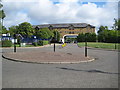
Southall: Chevy Road and the Comer Crescent arch
This land was once occupied by 20th century buildings belonging to St Bernard's Hospital, but while the original lunatic asylum buildings from the 1830s are largely intact, all the 20th century ones have been demolished and replaced with housing. The roundabout is at the junction of Chevy Road with Navigator Drive, while further up Chevy Road the Comer Crescent arch is visible.
Image: © Nigel Cox
Taken: 18 Aug 2013
0.07 miles
3
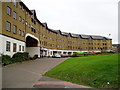
Comer Crescent from the entrance to Osterley Gardens
Image: © J Taylor
Taken: 2 Dec 2008
0.07 miles
4
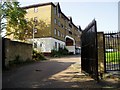
View from Osterley Gardens entrance to Comer Crescent
Image: © J Taylor
Taken: 28 Sep 2008
0.07 miles
7
Builders' supplies yard with caf
After a cold bike ride I wanted a cup of coffee, and was directed by the industrial estate gateman to Selco Builders' Supplies. The welcome cup of coffee only cost me 50 pence. Between Christmas and New Year there were few other customers.
Image: © David Hawgood
Taken: 29 Dec 2008
0.10 miles
8
Noon Products Ltd
At times the sickly smell of garlic can be detected on the air.
Image: © J Taylor
Taken: 1 Dec 2008
0.10 miles
9
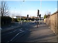
Pedestrian crossing on Windmill Lane
This crossing is on the approach to the Three Bridges if you were heading south.
Image: © J Taylor
Taken: 1 Feb 2009
0.10 miles
10
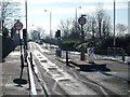
Approach to The Three Bridges - looking southwards
The Three Bridges is a unique transport intersection, designed and built by Isambard Kingdom Brunel. It was to be his last project before he died on 15th September 1859 just two months after its completion.
The correct name for it should be Windmill Bridge - named after the Southall Mill, which stood on the south-western side of the original canal bridge which was first built in the 1790's when the canal was cut. J.M.W. Turner painted this windmill in 1806.
http://commons.wikimedia.org/wiki/File:Joseph_Mallord_William_Turner_014.jpg
Known locally as Three Bridges, the name is a misnomer as there are in fact only two bridges - the road bridge over the canal and the canal bridge over the railway. The canal is conveyed through an 8 ft cast-iron trough over the
railway, with the road on a brick & cast-iron girder bridge above.
The Three Bridges was constructed as a result of the Brentford Branch line being built to connect the Great Western Railway at Southall to the docks at Brentford. Which was opened in July 1859. Brunel chose the location for the
Three Bridges intersection where the canal was already crossed by Windmill Lane.
The Three Bridges has been designated a Scheduled Ancient Monument by English Heritage. There is a 3 ton weight and 6' 6" width restrictions on the road bridge.
Image: © J Taylor
Taken: 4 Feb 2009
0.11 miles