IMAGES TAKEN NEAR TO
West Park Road, SOUTHALL, UB2 4UJ
Introduction
This page details the photographs taken nearby to West Park Road, UB2 4UJ by members of the Geograph project.
The Geograph project started in 2005 with the aim of publishing, organising and preserving representative images for every square kilometre of Great Britain, Ireland and the Isle of Man.

There are currently over 7.5m images from over14,400 individuals and you can help contribute to the project by visiting https://www.geograph.org.uk
Image Map
Images are licensed for reuse under creativecommons.org/licenses/by-sa/2.0
Notes
- Clicking on the map will re-center to the selected point.
- The higher the marker number, the further away the image location is from the centre of the postcode.
Image Listing (202 Images Found)
Images are licensed for reuse under creativecommons.org/licenses/by-sa/2.0
Image
Details
Distance
1
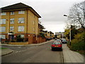
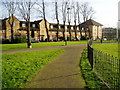
West Park Road, Wind Mill Estate, Southall - looking east
Ealing Hospital can be seen in the background.
Alderson Place is the junction off to the left.
Image: © J Taylor
Taken: 2 Dec 2008
0.01 miles
2
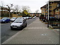
West Park Road, Wind Mill Estate, Southall - looking west
Image: © J Taylor
Taken: 2 Dec 2008
0.02 miles
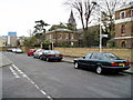
3
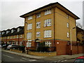
Alderson Place at junction with West Park Road, Wind Mill Estate, Southall
During the lead up to Christmas, usually starting sometime around late November, this building is festooned in illuminated Christmas decorations.
Image: © J Taylor
Taken: 2 Dec 2008
0.03 miles
4
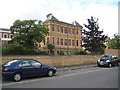
Hanwell: St Bernard's Hospital
St Bernard's Hospital, once the Middlesex County Lunatic Asylum and the first purpose-built asylum in England and Wales, was opened in 1831. There is a comprehensive history of the place in its Wikipedia article here http://en.wikipedia.org/wiki/Hanwell_Asylum
The building is Grade II Listed but only the original structure. Numerous wings and other appendages were built as time went by, and, unfortunately, the photographer has selected one of these to record. This wing is not present on the 1896 Ordnance Survey map, but is present on the edition of 1914. Part of the original female wing, now listed, can be glimpsed on the left.
Image: © Nigel Cox
Taken: 18 Aug 2013
0.03 miles
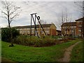
6
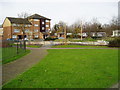
Children's Play Area, Windmill Estate, Southall
Adjacent to Ellis Road.
Image: © J Taylor
Taken: 2 Dec 2008
0.06 miles
7

Hanwell: St Bernard's Hospital Lodge and Chapel
These buildings are the West Lodge and, behind it, the Chapel to St Bernard's Hospital, once the Middlesex County Lunatic Asylum and the first purpose-built asylum in England and Wales, opening in 1831. There is a comprehensive history of the place in its Wikipedia article here http://en.wikipedia.org/wiki/Hanwell_Asylum
The lodge is shown on the Ordnance Survey map of 1868 so certainly dates from before. There was once an East Lodge too, but that has since been demolished.
The chapel is later, dating from 1880, and was built at the northern end of the asylum's original chapel.
Both the lodge and the chapel are Grade II Listed Buildings.
Image: © Nigel Cox
Taken: 18 Aug 2013
0.06 miles
8
West Park Road, Wind Mill Estate, Southall - looking east
Osterly Park is on the right (a private residential complex).
The spire is that of the St. Bernards' Hospital Chapel.
The blue building in the background is Ealing Hospital.
The road junction on the left is Halliday Square.
Image: © J Taylor
Taken: 2 Dec 2008
0.06 miles
9
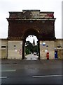
St. Bernard's Gatehouse entrance from the Uxbridge Road.
Image: © J Taylor
Taken: 30 Sep 2008
0.07 miles
10
Children's play area,Windmill Estate, Southall
The gap in the houses is Iron Bridge Close.
Image: © J Taylor
Taken: 2 Dec 2008
0.08 miles