IMAGES TAKEN NEAR TO
Waterside Road, SOUTHALL, UB2 4RA
Introduction
This page details the photographs taken nearby to Waterside Road, UB2 4RA by members of the Geograph project.
The Geograph project started in 2005 with the aim of publishing, organising and preserving representative images for every square kilometre of Great Britain, Ireland and the Isle of Man.

There are currently over 7.5m images from over14,400 individuals and you can help contribute to the project by visiting https://www.geograph.org.uk
Image Map
Images are licensed for reuse under creativecommons.org/licenses/by-sa/2.0
Notes
- Clicking on the map will re-center to the selected point.
- The higher the marker number, the further away the image location is from the centre of the postcode.
Image Listing (67 Images Found)
Images are licensed for reuse under creativecommons.org/licenses/by-sa/2.0
Image
Details
Distance
1

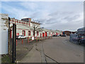
Bridge Road industrial estate, Southall
Image: © David Howard
Taken: 17 Aug 2013
0.08 miles
2
Bridge Road Industrial Estate
Originally part of the Maypole Dairy Co's margarine factory complex.
Image: © Alan Murray-Rust
Taken: 9 Jan 2012
0.09 miles
3
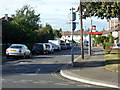
Gregory Road, Southall
The bus stop is Gregory Road. It is for the E5 service towards Toplocks Estate.
Image: © Robin Webster
Taken: 16 Sep 2012
0.11 miles
4
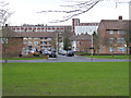
Havelock Estate
1950/60s local authority housing to the east of Southall Green.
Image: © Alan Murray-Rust
Taken: 9 Jan 2012
0.12 miles
5
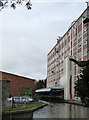
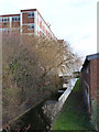
Maypole Dock
Built to serve the Maypole Dairy Co margarine factory. This is the former Quaker Oats (Puffed Wheat) factory, which also used the canal, using this canopied wharf.
Image: © Alan Murray-Rust
Taken: 9 Jan 2012
0.14 miles
6
Maypole Dock
Looking east from Bridge Road. This end of the branch appears to have been narrowed.
Image: © Alan Murray-Rust
Taken: 9 Jan 2012
0.14 miles
7
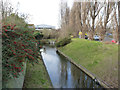
Maypole Dock
Looking west from Bridge Road. The canal used carry on a bit further and ended in a largish basin. The cut appears to have been retained for drainage and possibly cooling water purposes.
Image: © Alan Murray-Rust
Taken: 9 Jan 2012
0.14 miles
8
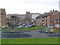
Playground at Havelock Estate
1950/60s local authority housing to the east of Southall Green. In the background is the former Quaker Oats factory, now Honey Monster Foods.
Image: © Alan Murray-Rust
Taken: 9 Jan 2012
0.15 miles
9

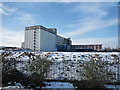
Honey Monster Foods Ltd (rear off) from Glade lane
Image: © J Taylor
Taken: 4 Feb 2009
0.15 miles
10
Honey Monster Foods Ltd (rear off) from Glade Lane
Image: © J Taylor
Taken: 4 Feb 2009
0.15 miles