IMAGES TAKEN NEAR TO
Lynhurst Crescent, UXBRIDGE, UB10 9EF
Introduction
This page details the photographs taken nearby to Lynhurst Crescent, UB10 9EF by members of the Geograph project.
The Geograph project started in 2005 with the aim of publishing, organising and preserving representative images for every square kilometre of Great Britain, Ireland and the Isle of Man.

There are currently over 7.5m images from over14,400 individuals and you can help contribute to the project by visiting https://www.geograph.org.uk
Image Map
Images are licensed for reuse under creativecommons.org/licenses/by-sa/2.0
Notes
- Clicking on the map will re-center to the selected point.
- The higher the marker number, the further away the image location is from the centre of the postcode.
Image Listing (26 Images Found)
Images are licensed for reuse under creativecommons.org/licenses/by-sa/2.0
Image
Details
Distance
1
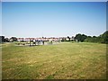
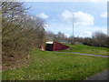
Recreation Ground
Exercise area with Houses in background in Windsor Avenue.
Image: © James Emmans
Taken: 25 Jul 2019
0.05 miles
2
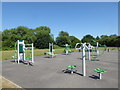
Keep fit equipment next to the Hillingdon Trail
The Hillingdon Trail is a 20 mile path through Hillingdon's countryside from Cranford in the south-east to Harefield in the north-west - see https://archive.hillingdon.gov.uk/article/8730/Yeading-Valley Here it is passing through a recreation ground between the A40 and Gutteridge Wood.
Image: © Marathon
Taken: 27 Jun 2018
0.06 miles
3
Exercise by the Hillingdon Trail
Fitness equipment on a recreation ground. The path is part of the Hillingdon Trail.
Image: © Des Blenkinsopp
Taken: 9 Oct 2014
0.07 miles
4
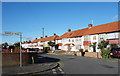
Lynhurst Crescent
Junction with Berkeley Road.
Image: © Des Blenkinsopp
Taken: 28 Nov 2017
0.09 miles
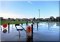
5
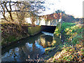
Bridge over the Yeading Brook
The brook emerges from passing under the A40 slip road, verges and cycle track via a culvert.
Image: © Robin Webster
Taken: 18 Jan 2015
0.10 miles
6
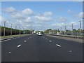
A40 - short lights at Northolt aerodrome
The unmistakeable "shrunken" lights provided alongside the extended centreline of RAF Northolt's runway. Although not obvious, the lights are also shrouded to minimise visibility from aircraft landing or taking off.
Image: © Peter Whatley
Taken: 12 Apr 2011
0.11 miles
7
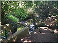
Yeading Brook
The Brook is quite well hidden with this being a visible part.
Part of the Hillingdon Trail.
Image: © James Emmans
Taken: 25 Jul 2019
0.14 miles
8
Looking up to the original line of the A40
This view looks across a footpath and cycle track to Western Avenue which is at the top of the embankment and passing over the subway. Western Avenue here was the original A40 before it was re-routed to the north to pass under Long Lane in a cutting. Western Avenue here is now just a slip road.
Image: © Marathon
Taken: 14 Mar 2018
0.14 miles
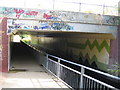
9
Subway under A40 slip road
This is on the Hillingdon Trail. The path the other side is not as wonderful.
Image: © Robin Webster
Taken: 18 Jan 2015
0.14 miles
10
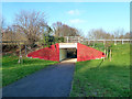
Yeading Brook, The Hillingdon Trail & the A40 subway
Three for the price of one here. The A40 Western Avenue finally bypassed the bottleneck of the Master Brewer / Long Lane junction in the 1990s, and this is the bridge carrying the new road over both the Hillingdon Trail and Yeading Brook.
Image: © Nigel Cox
Taken: 20 Jul 2006
0.15 miles