IMAGES TAKEN NEAR TO
Hoylake Crescent, UXBRIDGE, UB10 8JF
Introduction
This page details the photographs taken nearby to Hoylake Crescent, UB10 8JF by members of the Geograph project.
The Geograph project started in 2005 with the aim of publishing, organising and preserving representative images for every square kilometre of Great Britain, Ireland and the Isle of Man.

There are currently over 7.5m images from over14,400 individuals and you can help contribute to the project by visiting https://www.geograph.org.uk
Image Map
Images are licensed for reuse under creativecommons.org/licenses/by-sa/2.0
Notes
- Clicking on the map will re-center to the selected point.
- The higher the marker number, the further away the image location is from the centre of the postcode.
Image Listing (11 Images Found)
Images are licensed for reuse under creativecommons.org/licenses/by-sa/2.0
Image
Details
Distance

2
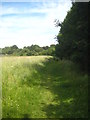
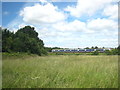
Footpath along the edge of the field
On a small area of common land adjacent to the railway at Ickenham.
Image: © Rod Allday
Taken: 30 Jun 2013
0.18 miles
3
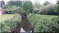
River Pinn
River Pinn by Copthall Road West
Image: © Shaun Ferguson
Taken: 17 May 2019
0.19 miles
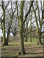
5
Pynchester Moat
Part of the Pynchester Moat, a Scheduled Ancient Monument on the River Pinn just east of Copthall Road West. Although usually dry in the summer months, the moat surrounding the location of a manor house can still be seen.
Image: © Ian Harrison
Taken: 10 Apr 2011
0.20 miles
6
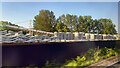
HS2 works, West Ruislip, May 2023 – linings
The photograph was taken from a Birmingham-bound Chiltern Railways service speeding out of Marylebone; the view is back toward the HS2 works at West Ruislip where the line will emerge from under west London at the western portal of the Northolt Tunnels.
What follows is partly speculation. The photo shows stacks of up to seven precast concrete tunnel linings; seven segments lock together to form a complete ring. The segments are put in place automatically by a unit in the tunnel boring machine (TBM) as it proceeds. The HS2 website has a number of YouTube videos about TBMs (and much else): https://www.hs2.org.uk/building-hs2/tunnels/meet-our-giant-tunnel-boring-machines/ The structure in the left background carries – let’s call them pods – which can be loaded with segments by travelling crane and rolled down into the tunnel to replenish the TBM. This structure, and another, can be seen beyond the red locomotive in Image
This image reference: 7498538
Image: © Robin Stott
Taken: 26 May 2023
0.23 miles
8
A train on the mainline north of Ickenham
If all goes ahead as planned this line will be replaced by the HS2 high speed line from London to the Midlands and the North.
Image: © Rod Allday
Taken: 30 Jun 2013
0.23 miles
10
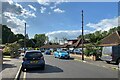
HS2 works, West Ruislip, May 2023 – The Greenway
The Greenway is a residential cul-de-sac south of and adjacent to the Chiltern main line out of Marylebone. The HS2 works are on the north side of the line. Through a gap in the trees one of the travelling cranes (just visible in the distance in Image) was seen moving away. Its motive power was audible. A resident remarked that noise from the HS2 works was a nuisance that had to be borne.
Image: © Robin Stott
Taken: 20 May 2023
0.24 miles