IMAGES TAKEN NEAR TO
Breakspear Road South, UXBRIDGE, UB10 8HB
Introduction
This page details the photographs taken nearby to Breakspear Road South, UB10 8HB by members of the Geograph project.
The Geograph project started in 2005 with the aim of publishing, organising and preserving representative images for every square kilometre of Great Britain, Ireland and the Isle of Man.

There are currently over 7.5m images from over14,400 individuals and you can help contribute to the project by visiting https://www.geograph.org.uk
Image Map
Images are licensed for reuse under creativecommons.org/licenses/by-sa/2.0
Notes
- Clicking on the map will re-center to the selected point.
- The higher the marker number, the further away the image location is from the centre of the postcode.
Image Listing (6 Images Found)
Images are licensed for reuse under creativecommons.org/licenses/by-sa/2.0
Image
Details
Distance
1

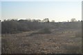
Copthall Farm
An old farm house with a farm shop and other units in the yard behind.
Image: © Des Blenkinsopp
Taken: 16 Jul 2014
0.03 miles
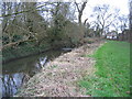
2
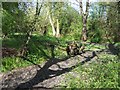
Pynchester Moat
Part of the Pynchester Moat, a Scheduled Ancient Monument on the River Pinn just east of Copthall Road West. Although usually dry in the summer months, the moat surrounding the location of a manor house can still be seen.
Image: © Ian Harrison
Taken: 10 Apr 2011
0.18 miles
3
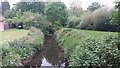
River Pinn
River Pinn by Copthall Road West
Image: © Shaun Ferguson
Taken: 17 May 2019
0.21 miles
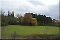
5
River Pinn. looking towards Swakeleys Road, Ickenham
Image: © Pip Rolls
Taken: 20 Jan 2005
0.24 miles