IMAGES TAKEN NEAR TO
Pole Hill Road, UXBRIDGE, UB10 0QD
Introduction
This page details the photographs taken nearby to Pole Hill Road, UB10 0QD by members of the Geograph project.
The Geograph project started in 2005 with the aim of publishing, organising and preserving representative images for every square kilometre of Great Britain, Ireland and the Isle of Man.

There are currently over 7.5m images from over14,400 individuals and you can help contribute to the project by visiting https://www.geograph.org.uk
Image Map
Images are licensed for reuse under creativecommons.org/licenses/by-sa/2.0
Notes
- Clicking on the map will re-center to the selected point.
- The higher the marker number, the further away the image location is from the centre of the postcode.
Image Listing (12 Images Found)
Images are licensed for reuse under creativecommons.org/licenses/by-sa/2.0
Image
Details
Distance
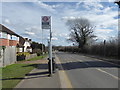
1
Turner Close bus stop
Served by route U7 from Uxbridge towards Hayes Town.
Image: © Robin Webster
Taken: 18 Jan 2015
0.08 miles
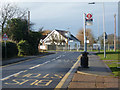
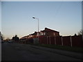
2
Pole Hill Road
Pole Hill Road comes in from the near left as a major road, but the main route swings to the right as Charvill Lane. Straight on is a dead-end serving a school and some houses.
Image: © Robin Webster
Taken: 18 Jan 2015
0.08 miles
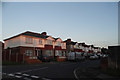
3
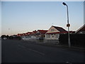
Chalet bungalows on Pole Hill Road
These are very unusual designs for Britain, and were probably built in around the 30s-40s.
Image: © David Howard
Taken: 9 Nov 2014
0.11 miles
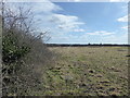
4
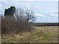
Field next to Charville Lane
Charville Lane is to the left of the hedge. It drops down ahead into the valley of the Yeading Brook and gives distant views beyond to London. These rough fields are accessible by a stile just behind where I am standing.
Image: © Marathon
Taken: 14 Mar 2018
0.12 miles
5
Field next to Charville Lane
Charville Lane is to the left of the hedge. It drops down ahead into the valley of the Yeading Brook and gives distant views beyond to London. These rough fields are accessible by a stile just behind where I am standing.
Image: © Marathon
Taken: 14 Mar 2018
0.14 miles
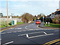
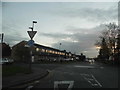
6
Bus stop on Charville Lane
Charville Lane drops down ahead into the valley of the Yeading Brook and gives distant views beyond to London. The area to the right is at present an area of rough fields which is accessible by a stile just behind where I am standing
Image: © Marathon
Taken: 14 Mar 2018
0.14 miles
7
Pole Hill Road at the junction of Mellow Lane West
Image: © David Howard
Taken: 9 Nov 2014
0.14 miles
8
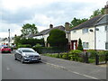
Houses in Marlborough Road Hillingdon Heath
Image: © Rod Allday
Taken: 20 May 2019
0.17 miles
10
Houses on Towers Avenue, Hillingdon
From the corner of Pole Hill Road
Image: © David Howard
Taken: 9 Nov 2014
0.22 miles