IMAGES TAKEN NEAR TO
Bader Way, UXBRIDGE, UB10 0FW
Introduction
This page details the photographs taken nearby to Bader Way, UB10 0FW by members of the Geograph project.
The Geograph project started in 2005 with the aim of publishing, organising and preserving representative images for every square kilometre of Great Britain, Ireland and the Isle of Man.

There are currently over 7.5m images from over14,400 individuals and you can help contribute to the project by visiting https://www.geograph.org.uk
Image Map
Images are licensed for reuse under creativecommons.org/licenses/by-sa/2.0
Notes
- Clicking on the map will re-center to the selected point.
- The higher the marker number, the further away the image location is from the centre of the postcode.
Image Listing (46 Images Found)
Images are licensed for reuse under creativecommons.org/licenses/by-sa/2.0
Image
Details
Distance
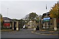
1
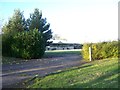
RAF Uxbridge sports centre
The former sports centre and track at RAF Uxbridge. This is due to be demolished by the end of 2013 to make way for a new primary school.
Image: © Ian Harrison
Taken: 11 Nov 2012
0.01 miles
2
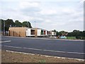
The John Locke Academy, Uxbridge
The John Locke Academy, a new primary school built on the site of the athletics track and gym of RAF Uxbridge (Image) The new school opened to its first intake of pupils in September 2014. A new road connecting the school on St Andrew's Road with Park Road was also built. As a result, a section of St Andrew's Road has been rerouted, and the public footpath passing along the road, beginning at St Andrew's Gate has been closed while construction work continues.
Image: © Ian Harrison
Taken: 28 Sep 2014
0.02 miles
3

Demolished RAF Uxbridge sports centre
The site of the RAF Uxbridge sports centre, demolished in April 2013. This is an update for Image from November 2012. The site is due to become a new primary school for the area.
Image: © Ian Harrison
Taken: 25 Apr 2013
0.03 miles
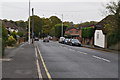
4
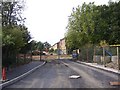
RAF Hospital Uxbridge development
The former RAF Hospital Uxbridge, currently undergoing conversion to become new housing. New access road is shown partially complete, this will link the development with St Andrew's Road from The John Locke academy.
Image: © Ian Harrison
Taken: 28 Sep 2014
0.08 miles
8
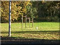
Chinning bars at RAF Uxbridge
Exercise equipment in the former RAF station.
Image: © Ian Harrison
Taken: 11 Nov 2012
0.11 miles
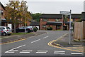
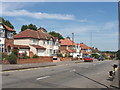
10
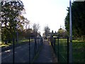
Footpath along St Andrew's Road
Fenced footpath along St Andrew's Road within the former RAF Uxbridge station. The path reopened in 2011, having been closed to the public since 1988.
Image: © Ian Harrison
Taken: 11 Nov 2012
0.11 miles