IMAGES TAKEN NEAR TO
Orchard Road, RICHMOND, TW9 4FG
Introduction
This page details the photographs taken nearby to Orchard Road, TW9 4FG by members of the Geograph project.
The Geograph project started in 2005 with the aim of publishing, organising and preserving representative images for every square kilometre of Great Britain, Ireland and the Isle of Man.

There are currently over 7.5m images from over14,400 individuals and you can help contribute to the project by visiting https://www.geograph.org.uk
Image Map
Images are licensed for reuse under creativecommons.org/licenses/by-sa/2.0
Notes
- Clicking on the map will re-center to the selected point.
- The higher the marker number, the further away the image location is from the centre of the postcode.
Image Listing (102 Images Found)
Images are licensed for reuse under creativecommons.org/licenses/by-sa/2.0
Image
Details
Distance
1

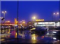
Sainsbury's, Richmond
This is a large Sainsbury site, strategically sited just off the A316 and close to North Sheen station, and includes a Homebase DIY store and filling station.
Image: © Stephen Craven
Taken: 22 Jul 2010
0.04 miles
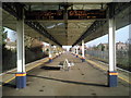
2

North Sheen Station
Long platforms are needed for the ten coach trains that run the suburban commuter routes in and out of Waterloo
Image: © Des Blenkinsopp
Taken: 26 Feb 2020
0.05 miles
3
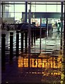
A wet night at Sainsbury's, Richmond
The supermarket seen from the car park, on a drizzly evening. The rain seemed very welcome, after a long, frosty December.
Image: © Stefan Czapski
Taken: 29 Dec 2010
0.06 miles
4
Sainsbury's, Manor Road, Richmond
The Sainsbury's site lies in the angle between the A316 and Manor Road. This is the view looking eastward from Manor Road. To the left of the supermarket, next to the A316, is a Sainsbury's filling station.
Taken on a mild, drizzly evening, following a long cold spell with snow on the ground.
Image: © Stefan Czapski
Taken: 29 Dec 2010
0.07 miles
5

Richmond Fire Station
On the south side of the A316 dual carriageway. See also Image I looked back at an older edition of the London A-Z and this was the A3003 when the street atlas was published (1986), with the A316 at that time being routed up Kew Road (now A307).
Image: © Stephen Craven
Taken: 22 Jul 2010
0.07 miles
6
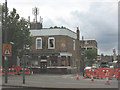
The Shakespeare, Lower Richmond Road
A Young's pub on the corner of Orchard Road.
Image: © Stephen Craven
Taken: 22 Jul 2010
0.07 miles
7
Richmond Fire Station, Lower Richmond Road (A316)
Taken from the footbridge.
Image: © Noel Foster
Taken: 30 Aug 2005
0.07 miles
8

Approach to the platform at North Sheen station
There is a central platform at North Sheen, reached by a footpath and footbridge from Manor Road. This view looks up the line towards Mortlake and onwards to Clapham Junction and Waterloo.
Image: © Marathon
Taken: 19 Jan 2011
0.07 miles
9

Footbridge over Lower Richmond Road (A316)
Image: © Noel Foster
Taken: 30 Aug 2005
0.07 miles
10
Platform at North Sheen station
There is a central platform at North Sheen, reached by a footpath and footbridge from Manor Road. This view looks up the line towards Mortlake and onwards to Clapham Junction and Waterloo.
Image: © Marathon
Taken: 19 Jan 2011
0.08 miles