IMAGES TAKEN NEAR TO
High Street, BRENTFORD, TW8 8AQ
Introduction
This page details the photographs taken nearby to High Street, TW8 8AQ by members of the Geograph project.
The Geograph project started in 2005 with the aim of publishing, organising and preserving representative images for every square kilometre of Great Britain, Ireland and the Isle of Man.

There are currently over 7.5m images from over14,400 individuals and you can help contribute to the project by visiting https://www.geograph.org.uk
Image Map
Images are licensed for reuse under creativecommons.org/licenses/by-sa/2.0
Notes
- Clicking on the map will re-center to the selected point.
- The higher the marker number, the further away the image location is from the centre of the postcode.
Image Listing (396 Images Found)
Images are licensed for reuse under creativecommons.org/licenses/by-sa/2.0
Image
Details
Distance
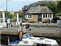
1
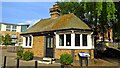
Canal toll house
Built in 1911, this building was where lock keepers calculated the tolls for passing barges. Known as 'gauging', this entailed measuring how low a vessel sat in the water. This was done with a 'gauging rod' - a pole with a float attached.
The building's splayed windows are designed to give views of approaching boats.
A grade II listed building, the toll house has been restored as a small museum by the Canal & River Trust and is staffed by volunteers.
Image: © Mark Percy
Taken: 30 Apr 2022
0.01 miles
3
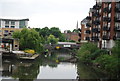
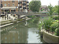
River Brent and Brentford Gauging Locks
The River Brent and the Grand Union Canal share a common course for large parts of their route below Hanwell Locks and both join the Thames at the same place in Brentford. The River Brent is on the right here, whilst the Grand Union Canal passes through Brentford Gauging Locks on the left. At the gauging locks the toll clerk checked to see how much cargo each boat was carrying so that he knew how much toll they should pay to use the canal. To do this he used a special stick known as a gauging rod to measure how high out of the water the boat was sitting. From this he could calculate the weight of cargo on board.
Image: © Marathon
Taken: 2 Nov 2011
0.01 miles
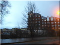
4
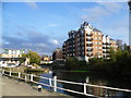
Ironside Road bridge
The bridge in the centre of the photo takes Ironside Road across the River Brent. Viewed from the southern end of Brentford Bridge. There are several modern apartment blocks on the riverside.
Image: © Stephen Craven
Taken: 30 Apr 2011
0.02 miles
5

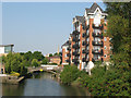
The River Brent below Brentford Weir
View downstream at a point close to the gauging locks. Notice the luxuriant growth of umbellifers along the river bank on the left.
Image: © Stefan Czapski
Taken: 18 Jun 2014
0.02 miles
6
Footbridge over the Brent
An attractive modern laminated timber footbridge over the river channel at the back of Brentford Gauging Locks. The inflow of water from the sluices in Image can just be detected at the top of the area of reflection of the sky. River flow was very low on the day concerned.
Image: © Alan Murray-Rust
Taken: 23 Jul 2008
0.02 miles
8
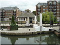
Brentford Gauging Locks
The top gates with the Toll Office in the background. Craft would be gauged while passing through the lock to assess the toll on their cargo. At some point in its life each boat would have its freeboard measured with known weights of load. This would then allow a full and empty entry to be made in a register; on subsequent visits a measurement of freeboard would enable the weight of cargo on that run to be calculated.
Image: © Alan Murray-Rust
Taken: 23 Jul 2008
0.03 miles
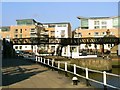
10
Old tollhouse at Brentford Gauging Locks
A grade II listed building of 1911. This was presumably built when the lock was doubled, which happened some time around then according to old maps.
Image: © Robin Webster
Taken: 9 Sep 2012
0.03 miles