IMAGES TAKEN NEAR TO
Grosvenor Road, BRENTFORD, TW8 0NW
Introduction
This page details the photographs taken nearby to Grosvenor Road, TW8 0NW by members of the Geograph project.
The Geograph project started in 2005 with the aim of publishing, organising and preserving representative images for every square kilometre of Great Britain, Ireland and the Isle of Man.

There are currently over 7.5m images from over14,400 individuals and you can help contribute to the project by visiting https://www.geograph.org.uk
Image Map (Loading...)


Getting Data...Please wait
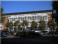
Leaflet Map data © OpenStreetMap
Images are licensed for reuse under creativecommons.org/licenses/by-sa/2.0
Notes
- Clicking on the map will re-center to the selected point.
- The higher the marker number, the further away the image location is from the centre of the postcode.
Image Listing (347 Images Found)
Images are licensed for reuse under creativecommons.org/licenses/by-sa/2.0
Image
Details
Distance
1
Grosvenor Road, Brentford
Looking towards Brook Road South from the footpath alongside the recreation ground, with the high rise flats off Green Dragon Lane towering over the horizon.
Image: © Richard Vince
Taken: 3 Nov 2017
0.02 miles
2
Albany Road, Brentford (1)
Looking towards Ealing Road from round the back of Albany Parade.
Image: © Richard Vince
Taken: 3 Nov 2017
0.04 miles
3
Footpath alongside the recreation ground, Brentford
Leading from Albany Road to Lateward Road, via the end of Grosvenor Road.
Image: © Richard Vince
Taken: 3 Nov 2017
0.05 miles
4
Albany Road, Brentford (2)
Looking towards Ealing Road from the east end of the recreation ground.
Image: © Richard Vince
Taken: 3 Nov 2017
0.05 miles
5
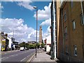
View of the Kew Bridge Steam Museum tower from Brentford High Street
Looking north-northeast.
Image: © Robert Lamb
Taken: 6 Jul 2011
0.05 miles
6
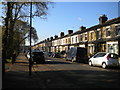
Lateward Road, Brentford
Along the north side of the recreation ground.
Image: © Richard Vince
Taken: 3 Nov 2017
0.06 miles
7
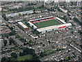
Griffin Park from the air
Taken from a Heathrow bound flight from Glasgow on a grey August day. The home of Brentford FC http://www.brentfordfc.co.uk/ .
Image: © Thomas Nugent
Taken: 10 Aug 2016
0.07 miles
8
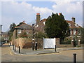
The Butts
In the heart of Brentford, and deserving to be better known, are The Butts, a street and square of red brick houses developed from the 1680s. The houses bear comparison, in their more modest way, with their contemporaries around Salisbury cathedral close, and their leafy gardens provide some echo of the 'seat of paradise' the area was once considered to be.
Image: © Mark Percy
Taken: 31 Mar 2007
0.07 miles
9
Charlton House, Brentford
A block of flats with shops underneath.
Image: © Richard Vince
Taken: 3 Nov 2017
0.08 miles
10
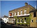
A pub on every corner, Brentford (1)
The Griffin, on the corner of Brook Road South (foreground) and Braemar Road, just across the latter from the south corner of Griffin Park, the home ground of Brentford Football Club. Griffin Park is known for being the only football ground in England with a pub at each corner; it takes its name from this establishment, which provided the club with dressing rooms when the ground first opened.
Image: © Richard Vince
Taken: 3 Nov 2017
0.08 miles