IMAGES TAKEN NEAR TO
Glenhurst Road, BRENTFORD, TW8 0FE
Introduction
This page details the photographs taken nearby to Glenhurst Road, TW8 0FE by members of the Geograph project.
The Geograph project started in 2005 with the aim of publishing, organising and preserving representative images for every square kilometre of Great Britain, Ireland and the Isle of Man.

There are currently over 7.5m images from over14,400 individuals and you can help contribute to the project by visiting https://www.geograph.org.uk
Image Map
Images are licensed for reuse under creativecommons.org/licenses/by-sa/2.0
Notes
- Clicking on the map will re-center to the selected point.
- The higher the marker number, the further away the image location is from the centre of the postcode.
Image Listing (152 Images Found)
Images are licensed for reuse under creativecommons.org/licenses/by-sa/2.0
Image
Details
Distance
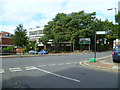
2
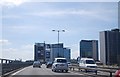
London : Brentford - Great West Road
The Great West Road A4 runs below the M4 Motorway where this photo was taken.
Image: © Lewis Clarke
Taken: 15 Aug 2010
0.03 miles
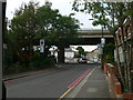
3
The M4 flying over Brentford
The M4 on stilts over the Great West Road (A4).
Image: © Eirian Evans
Taken: 12 Oct 2011
0.05 miles
5
Looking across Windmill Road (B452) from York Road
Image: © Shazz
Taken: 18 Sep 2013
0.07 miles
6

Forthcoming attraction on the Great West Road, Brentford
Image: © David Howard
Taken: 11 Sep 2022
0.07 miles
7
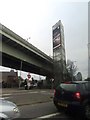
Looking up Windmill Road (B452)
The bridge ahead carries the M4, which runs parallel with, but above, the A4 Great West Road.
Image: © Eirian Evans
Taken: 12 Oct 2011
0.07 miles
8
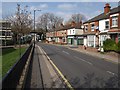
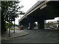
Windmill Road
The B455 passes York Road (right) and Glenhurst Road (left) as it approaches the A4, with the M4 running above on a flyover.
Image: © Derek Harper
Taken: 15 Apr 2010
0.08 miles
9
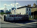
Performance Cars - Windmill Road, Ealing
Address: 90-94 Windmill Road, Brentford, TW8 9NA (at junction with the Great west Road).
This property has been unoccupied for years. The top of the perimeter wall is studded with broken glass.
It is the suspected site of the Flush Bracket S0925. (These are metal plates cemented flush into the faces of buildings. You can also find them on triangulation pillars. Flush Brackets are a type of bench mark. Each has a number on it, but this is just a serial number and does not give the height above sea level).
This flush bracket was used during the Re-levelling of Greater London, and was levelled with a height of 41.1640 feet [12.5468 metres] above mean sea level (Newlyn datum). It was included on the Staines to British Museum levelling line. The surveyor's description was Flush Bracket on S. face of bldg., near junc. of Great West Rd. & Windmill Rd.
Image: © J Taylor
Taken: 8 Oct 2008
0.09 miles
10
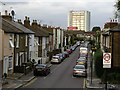
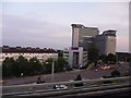
Orchard Road, Brentford
An interesting street scene, with a variety of terraced houses contrasting with the tower block in the distance. In the north of the square.
Image: © Peter Jordan
Taken: 25 Sep 2005
0.09 miles