IMAGES TAKEN NEAR TO
Linkfield Road, ISLEWORTH, TW7 6QN
Introduction
This page details the photographs taken nearby to Linkfield Road, TW7 6QN by members of the Geograph project.
The Geograph project started in 2005 with the aim of publishing, organising and preserving representative images for every square kilometre of Great Britain, Ireland and the Isle of Man.

There are currently over 7.5m images from over14,400 individuals and you can help contribute to the project by visiting https://www.geograph.org.uk
Image Map
Images are licensed for reuse under creativecommons.org/licenses/by-sa/2.0
Notes
- Clicking on the map will re-center to the selected point.
- The higher the marker number, the further away the image location is from the centre of the postcode.
Image Listing (107 Images Found)
Images are licensed for reuse under creativecommons.org/licenses/by-sa/2.0
Image
Details
Distance
9
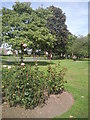
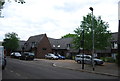
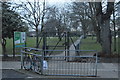
St John's Gardens, Isleworth
This small park is accessed from Linkfield Road.
Image: © Marathon
Taken: 22 Sep 2010
0.05 miles
10
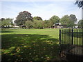
St John's Gardens
This view looks across the park from near St John's Road. An old pump is within the railings on the right. The houses in the distance are in Linkfield Road.
Image: © Marathon
Taken: 22 Sep 2010
0.06 miles