IMAGES TAKEN NEAR TO
Burns Way, HOUNSLOW, TW5 9BB
Introduction
This page details the photographs taken nearby to Burns Way, TW5 9BB by members of the Geograph project.
The Geograph project started in 2005 with the aim of publishing, organising and preserving representative images for every square kilometre of Great Britain, Ireland and the Isle of Man.

There are currently over 7.5m images from over14,400 individuals and you can help contribute to the project by visiting https://www.geograph.org.uk
Image Map
Images are licensed for reuse under creativecommons.org/licenses/by-sa/2.0
Notes
- Clicking on the map will re-center to the selected point.
- The higher the marker number, the further away the image location is from the centre of the postcode.
Image Listing (17 Images Found)
Images are licensed for reuse under creativecommons.org/licenses/by-sa/2.0
Image
Details
Distance
1
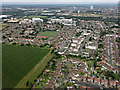
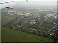
West Hounslow from the air
The turning circle in the foreground is at Burns Way.
Image: © Thomas Nugent
Taken: 10 Aug 2016
0.01 miles
2
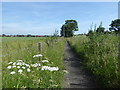
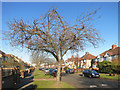
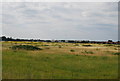
Footpath alongside a field
The field on the left has somehow stayed clear of development. It is north of Bath Road but is not accessible - this closed footpath runs along its eastern side. See also https://www.geograph.org.uk/photo/5799272
Image: © Marathon
Taken: 6 Jun 2018
0.05 miles
3
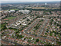
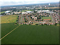
Heston from the air
Ash Grove and Norman Crescent are prominent.
Image: © Thomas Nugent
Taken: 10 Aug 2016
0.08 miles
5
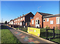
Brabazon Road Community Centre
Home to a play school as well, by the look of it.
Image: © Des Blenkinsopp
Taken: 29 Nov 2016
0.17 miles
6
West Hounslow from the air
Arable fields with Brabazon Road in the background.
Image: © Thomas Nugent
Taken: 10 Aug 2016
0.18 miles
8
Fields by the A4 from the air.
The houses are at Brabazon Road.
Image: © Thomas Nugent
Taken: 21 Dec 2013
0.18 miles
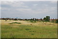
10
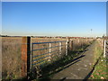
Footpath beside a field
The blank space on the map just here is farmland. Not exactly typical land use for suburban West London, but there are two or three fields still growing crops.
This path runs along the edge.
Image: © Des Blenkinsopp
Taken: 29 Nov 2016
0.20 miles