IMAGES TAKEN NEAR TO
Westbrook Road, HOUNSLOW, TW5 0NG
Introduction
This page details the photographs taken nearby to Westbrook Road, TW5 0NG by members of the Geograph project.
The Geograph project started in 2005 with the aim of publishing, organising and preserving representative images for every square kilometre of Great Britain, Ireland and the Isle of Man.

There are currently over 7.5m images from over14,400 individuals and you can help contribute to the project by visiting https://www.geograph.org.uk
Image Map
Images are licensed for reuse under creativecommons.org/licenses/by-sa/2.0
Notes
- Clicking on the map will re-center to the selected point.
- The higher the marker number, the further away the image location is from the centre of the postcode.
Image Listing (60 Images Found)
Images are licensed for reuse under creativecommons.org/licenses/by-sa/2.0
Image
Details
Distance
1
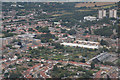
London : Hounslow - City Scenery
Looking down towards the London suburbs from an inbound plane to Heathrow.
Image: © Lewis Clarke
Taken: 6 Sep 2016
0.04 miles
2
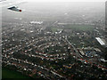
Heston from the air
Just visible through the low mid-winter day cloud. Westbrook Primary School http://www.westbrookprimary.com/ is on the right.
Image: © Thomas Nugent
Taken: 21 Dec 2013
0.11 miles
10
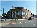
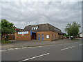
Hounslow Seventhday Adventist Church
It looks very much like it was originally built as a bank
Image: © Alexander P Kapp
Taken: 22 Jul 2012
0.19 miles