IMAGES TAKEN NEAR TO
Basildene Road, HOUNSLOW, TW4 7LU
Introduction
This page details the photographs taken nearby to Basildene Road, TW4 7LU by members of the Geograph project.
The Geograph project started in 2005 with the aim of publishing, organising and preserving representative images for every square kilometre of Great Britain, Ireland and the Isle of Man.

There are currently over 7.5m images from over14,400 individuals and you can help contribute to the project by visiting https://www.geograph.org.uk
Image Map
Images are licensed for reuse under creativecommons.org/licenses/by-sa/2.0
Notes
- Clicking on the map will re-center to the selected point.
- The higher the marker number, the further away the image location is from the centre of the postcode.
Image Listing (22 Images Found)
Images are licensed for reuse under creativecommons.org/licenses/by-sa/2.0
Image
Details
Distance

2
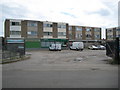
Hounslow: Beavers Farm Estate shops
These shops are on Chinchilla Drive.
Image: © Nigel Cox
Taken: 8 May 2011
0.10 miles
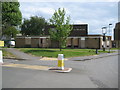
3
Entrance to The Hub sports centre, Hounslow
Image: © David Howard
Taken: 15 Sep 2019
0.11 miles
4
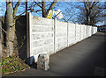
Boundary Stone on Beavers Lane
Behind the wall is Cavalry Barracks, a military site from Victorian times. This is at the south west corner and I would guess the stone marks the end of MOD land. It is inscribed WL with an arrow and N???D below, too worn away to read.
Image: © Des Blenkinsopp
Taken: 28 Jan 2019
0.11 miles
5
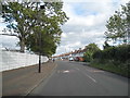
Beavers Lane, Hounslow
Hounslow Barracks are on the left, hence the security
Image: © David Howard
Taken: 11 May 2014
0.12 miles
6
Hounslow: The former Beaver public house
The Beaver seems to have closed its doors to business in 2009, although an article written in a November 2010 edition of the local Hounslow paper http://www.hounslowchronicle.co.uk/west-london-news/local-hounslow-news/2010/11/24/pub-reopening-will-be-boost-for-beavers-estate-109642-27708457/ stated that it was hoped that new owners would open it again in early 2011, but that is now several months ago.
Old Ordnance Survey maps show that this site, on the corner of Beavers Lane and Salisbury Road, was the location of Beavers Farm after which the nearby housing estate was named.
Image: © Nigel Cox
Taken: 8 May 2011
0.12 miles
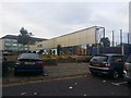
8
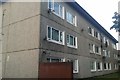
Concrete flats on Chinchilla Drive, Hounslow
Brutalism at its very finest
Image: © David Howard
Taken: 15 Sep 2019
0.13 miles
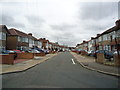
9
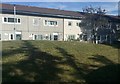
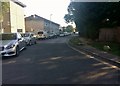
Houses on Chinchilla Drive, Hounslow
I was there for a while but I didn't see any chinchillas.
Image: © David Howard
Taken: 15 Sep 2019
0.13 miles