IMAGES TAKEN NEAR TO
Dawn Close, HOUNSLOW, TW4 7EN
Introduction
This page details the photographs taken nearby to Dawn Close, TW4 7EN by members of the Geograph project.
The Geograph project started in 2005 with the aim of publishing, organising and preserving representative images for every square kilometre of Great Britain, Ireland and the Isle of Man.

There are currently over 7.5m images from over14,400 individuals and you can help contribute to the project by visiting https://www.geograph.org.uk
Image Map
Images are licensed for reuse under creativecommons.org/licenses/by-sa/2.0
Notes
- Clicking on the map will re-center to the selected point.
- The higher the marker number, the further away the image location is from the centre of the postcode.
Image Listing (99 Images Found)
Images are licensed for reuse under creativecommons.org/licenses/by-sa/2.0
Image
Details
Distance
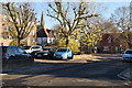
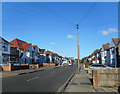
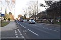
1
Martindale Road
Viewed from Bath Road. Note the sewer vent pipe on the left.
Image: © Thomas Nugent
Taken: 21 Feb 2011
0.01 miles
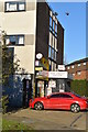
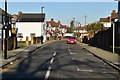
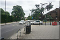
2
Bath Road
Martindale Road is to the left.
Image: © Thomas Nugent
Taken: 21 Feb 2011
0.02 miles
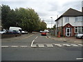
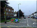
4
The northern end of Martindale Road
Here it meets Bath Road, the A3006. The spire of St Paul's Church is seen further down Bath Road.
Image: © Bill Boaden
Taken: 26 May 2022
0.02 miles