IMAGES TAKEN NEAR TO
Beavers Crescent, HOUNSLOW, TW4 6ET
Introduction
This page details the photographs taken nearby to Beavers Crescent, TW4 6ET by members of the Geograph project.
The Geograph project started in 2005 with the aim of publishing, organising and preserving representative images for every square kilometre of Great Britain, Ireland and the Isle of Man.

There are currently over 7.5m images from over14,400 individuals and you can help contribute to the project by visiting https://www.geograph.org.uk
Image Map
Images are licensed for reuse under creativecommons.org/licenses/by-sa/2.0
Notes
- Clicking on the map will re-center to the selected point.
- The higher the marker number, the further away the image location is from the centre of the postcode.
Image Listing (25 Images Found)
Images are licensed for reuse under creativecommons.org/licenses/by-sa/2.0
Image
Details
Distance
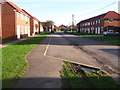
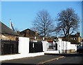
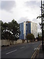
2
Beavers Lane, Hounslow
Hounslow Barracks are on the left, hence the security
Image: © David Howard
Taken: 11 May 2014
0.11 miles
3
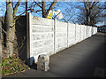
Boundary Stone on Beavers Lane
Behind the wall is Cavalry Barracks, a military site from Victorian times. This is at the south west corner and I would guess the stone marks the end of MOD land. It is inscribed WL with an arrow and N???D below, too worn away to read.
Image: © Des Blenkinsopp
Taken: 28 Jan 2019
0.12 miles
4
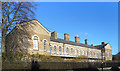
Part of Cavalry Barracks
Cavalry Barracks is a large Victorian military site in the middle of Hounslow. It is scheduled to close in 2020 and parts of it are already shut. A lot of the buildings are architecturally quite striking and will probably be retained.
Image: © Des Blenkinsopp
Taken: 28 Jan 2019
0.12 miles
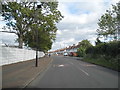
5
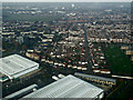
Hounslow from the air
Beavers Lane is in the foreground, with Basildene Road running into the distance.
Image: © Thomas Nugent
Taken: 24 Nov 2014
0.16 miles
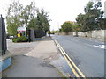
6
Gates to Cavalry Barracks
Cavalry Barracks is a large military site in the middle of Hounslow. It is scheduled to close in 2020 and as I walked past a lot of derelict buildings behind big fences I thought I would be able to get a picture through the gate of what's in there. Sadly, just by the gate were two soldiers with big guns so I had to pretend I wasn't a photographer and saunter on past. At least until they couldn't see me any more.
The last person to be flogged to death in the British army met his end here in 1846.
In 2007, MPs expressed concern in a report that some of the Victorian buildings at Cavalry Barracks were so bad that troops staying in tented camps in Afghanistan had better living conditions than those at Hounslow.
https://en.wikipedia.org/wiki/Cavalry_Barracks,_Hounslow
It's probably good it's closing.
Image: © Des Blenkinsopp
Taken: 28 Jan 2019
0.17 miles
7
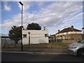
Art deco hut on Barrack Road
This is probably part of the large army camp opposite, but have no idea what it's being used for, if anything.
Image: © David Howard
Taken: 16 Aug 2014
0.17 miles
8
Green Lane, Hounslow
Virgin Atlantic's offices are on the left
Image: © David Howard
Taken: 27 Oct 2013
0.18 miles
9
Clements Court from Green Lane, Hounslow
There are many similar blocks across the borough, this is one of the smaller ones.
Image: © David Howard
Taken: 27 Oct 2013
0.19 miles
10
Pulborough Way, Hounslow
On the Green Lane industrial estate
Image: © David Howard
Taken: 27 Oct 2013
0.19 miles