IMAGES TAKEN NEAR TO
Simpson Road, HOUNSLOW, TW4 5QE
Introduction
This page details the photographs taken nearby to Simpson Road, TW4 5QE by members of the Geograph project.
The Geograph project started in 2005 with the aim of publishing, organising and preserving representative images for every square kilometre of Great Britain, Ireland and the Isle of Man.

There are currently over 7.5m images from over14,400 individuals and you can help contribute to the project by visiting https://www.geograph.org.uk
Image Map
Images are licensed for reuse under creativecommons.org/licenses/by-sa/2.0
Notes
- Clicking on the map will re-center to the selected point.
- The higher the marker number, the further away the image location is from the centre of the postcode.
Image Listing (12 Images Found)
Images are licensed for reuse under creativecommons.org/licenses/by-sa/2.0
Image
Details
Distance
2
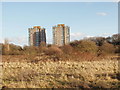
Flats by Hounslow Heath
The flats are near Hanworth Road. Photo taken looking east in afternoon sunshine from the London Loop path across the heath.
Image: © David Hawgood
Taken: 20 Jan 2006
0.05 miles
4
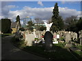
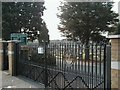
Hounslow Cemetery
Hounslow Cemetery off Hanworth Road
Image: © Shaun Ferguson
Taken: 15 Feb 2013
0.15 miles
5
Hounslow Cemetery, Hanworth Road
Opened in 1869, the cemetery is the final resting-place ‘Dunroamin’ for many operators of Fair Ground attractions and rides and boasts some fine memorial work.
Image: © Martin Elliff
Taken: 22 Sep 2005
0.18 miles
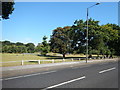
6
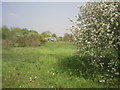
Hounslow Heath
Hounslow Heath once covered 4,000 acres but is now only 200 acres. However, it still has a feeling of spaciousness and is a very easy place to get lost. No doubt this was one of the features which made it a favourite haunt of highwaymen. The London LOOP crosses the Heath and this photograph was taken close to that path.
Image: © Marathon
Taken: 20 Apr 2011
0.20 miles
7
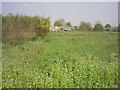
Hounslow Heath
Hounslow Heath once covered 4,000 acres but is now only 200 acres. However, it still has a feeling of spaciousness and is a very easy place to get lost. No doubt this was one of the features which made it a favourite haunt of highwaymen. The London LOOP crosses the Heath and this photograph was taken close to that path.
Image: © Marathon
Taken: 20 Apr 2011
0.20 miles
8
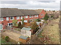
Back gardens of Mallard Close, Whitton
View north from the Stephenson Way bridge over the railway to Kew Bridge and Waterloo.
Image: © David Hawgood
Taken: 25 Jan 2006
0.21 miles
9
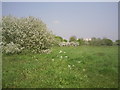
On Hounslow Heath
Hounslow Heath once covered 4,000 acres but is now only 200 acres. However, it still has a feeling of spaciousness and is a very easy place to get lost. No doubt this was one of the features which made it a favourite haunt of highwaymen.
Image: © Marathon
Taken: 20 Apr 2011
0.21 miles
10
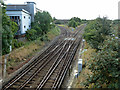
Hounslow Junction
The curve to Whitton Junction on the line towards Waterloo goes left, and to Feltham Junction on the line away from Waterloo, right.
Image: © Robin Webster
Taken: 14 Sep 2012
0.23 miles