IMAGES TAKEN NEAR TO
Bath Road, HOUNSLOW, TW3 3EJ
Introduction
This page details the photographs taken nearby to Bath Road, TW3 3EJ by members of the Geograph project.
The Geograph project started in 2005 with the aim of publishing, organising and preserving representative images for every square kilometre of Great Britain, Ireland and the Isle of Man.

There are currently over 7.5m images from over14,400 individuals and you can help contribute to the project by visiting https://www.geograph.org.uk
Image Map
Images are licensed for reuse under creativecommons.org/licenses/by-sa/2.0
Notes
- Clicking on the map will re-center to the selected point.
- The higher the marker number, the further away the image location is from the centre of the postcode.
Image Listing (26 Images Found)
Images are licensed for reuse under creativecommons.org/licenses/by-sa/2.0
Image
Details
Distance
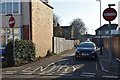
1
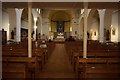
St Michael and Martin Church
On Bath Road, Hounslow.
Image: © Ian S
Taken: 15 Mar 2020
0.07 miles
2
St Michael and Martin Church
On Bath Road, Hounslow.
Image: © Ian S
Taken: 15 Mar 2020
0.08 miles
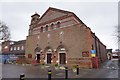
5
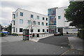
Heart of Hounslow Centre for Health
A clinic offering a number of health services. Just to the left is Hospital Road, so named because the former cottage hospital was at the other end of it.
Image: © Bill Boaden
Taken: 26 May 2022
0.14 miles
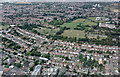
6
Allotments in Hounslow
Looking south from above the A4 to the allotments between Harte Road and Bulstrode Avenue, and the railway between Hounslow West and Hounslow Central.
Image: © M J Richardson
Taken: 24 Jun 2012
0.15 miles
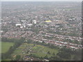
7
Lampton Park from the air
The park is in Hounslow and includes the Hounslow Civic Centre which is visible to the top right.
Image: © Thomas Nugent
Taken: 3 Aug 2015
0.16 miles
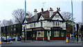
8
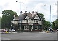
Hounslow: The Windsor Castle
Old Victorian Ordnance Survey maps show that there was a Windsor Castle public house here, at the junction of Bath Road with Wellington Road North, as early as 1865. The 1865 map also shows a Belgrave Brewery a little way south of the pub down Wellington Road North.
Image: © Nigel Cox
Taken: 8 May 2011
0.16 miles
10
Windsor Castle public house
On Bath Road at Wellington Road North.
Image: © Thomas Nugent
Taken: 21 Feb 2011
0.17 miles