IMAGES TAKEN NEAR TO
Wellesley Parade, Wellesley Road, TWICKENHAM, TW2 5SQ
Introduction
This page details the photographs taken nearby to Wellesley Parade, Wellesley Road, TW2 5SQ by members of the Geograph project.
The Geograph project started in 2005 with the aim of publishing, organising and preserving representative images for every square kilometre of Great Britain, Ireland and the Isle of Man.

There are currently over 7.5m images from over14,400 individuals and you can help contribute to the project by visiting https://www.geograph.org.uk
Image Map
Images are licensed for reuse under creativecommons.org/licenses/by-sa/2.0
Notes
- Clicking on the map will re-center to the selected point.
- The higher the marker number, the further away the image location is from the centre of the postcode.
Image Listing (117 Images Found)
Images are licensed for reuse under creativecommons.org/licenses/by-sa/2.0
Image
Details
Distance
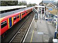
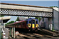
2
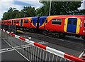
View of a Class 455 train approaching Strawberry Hill station #2
Looking north-northeast from the level crossing on Wellesley Road.
Image: © Robert Lamb
Taken: 16 Jul 2016
0.02 miles
3
Strawberry Hill
Northward view, from the level crossing.
Image: © Peter Trimming
Taken: 20 May 2024
0.02 miles
4
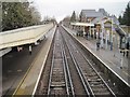
Strawberry Hill railway station, Greater London
Opened in 1875 by the London & South Western Railway on what is now the Twickenham to New Malden loop line.
View north towards Twickenham.
Image: © Nigel Thompson
Taken: 31 Jan 2015
0.02 miles
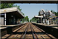
6
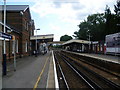
Strawberry Hill station
This view is from the southbound platform at Strawberry Hill station, although from both platforms you can end up at Waterloo. The line through Strawberry Hill (the Kingston Loop) opened in 1863, but Strawberry Hill station did not open until 1873. At the end of the platform is a level crossing on Tower Road but there is also a footbridge for when the gates are closed. Beyond the level crossing, the line straight ahead continues to Teddington, Kingston and Wimbledon, whilst the line to the right is the branch line to Shepperton.
Image: © Marathon
Taken: 29 Jun 2011
0.02 miles
7
Strawberry Hill Station
The distinctive footbridge by the level crossing at Strawberry Hill station.
Image: © Peter Kazmierczak
Taken: 21 Nov 2015
0.02 miles
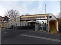
8
Footbridge at Strawberry Hill station
Bridge TSJ 5A/8 is very enclosed, even the lower open part of the span has steel close mesh, so it is useless for photography.
Image: © Robin Webster
Taken: 22 Sep 2012
0.02 miles
9
Strawberry Hill
Southwestern service, bound for Waterloo, leaving the platform.
Image: © Peter Trimming
Taken: 20 May 2024
0.02 miles
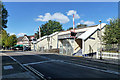
10
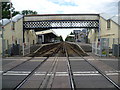
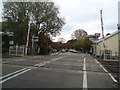
Strawberry Hill station from Tower Road
This view of Strawberry Hill station is from the level crossing on Tower Road. The line through Strawberry Hill (the Kingston Loop) opened in 1863, but Strawberry Hill station did not open until 1873.
Image: © Marathon
Taken: 29 Jun 2011
0.02 miles