IMAGES TAKEN NEAR TO
Fulwell Park Avenue, TWICKENHAM, TW2 5HB
Introduction
This page details the photographs taken nearby to Fulwell Park Avenue, TW2 5HB by members of the Geograph project.
The Geograph project started in 2005 with the aim of publishing, organising and preserving representative images for every square kilometre of Great Britain, Ireland and the Isle of Man.

There are currently over 7.5m images from over14,400 individuals and you can help contribute to the project by visiting https://www.geograph.org.uk
Image Map
Images are licensed for reuse under creativecommons.org/licenses/by-sa/2.0
Notes
- Clicking on the map will re-center to the selected point.
- The higher the marker number, the further away the image location is from the centre of the postcode.
Image Listing (30 Images Found)
Images are licensed for reuse under creativecommons.org/licenses/by-sa/2.0
Image
Details
Distance
5
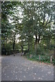
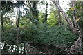
Bridge over the River Crane, Twickenham
Crane Park is built on an island on the river
Image: © David Howard
Taken: 9 Oct 2018
0.10 miles
6
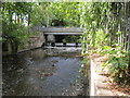
Weir on the River Crane
The bridge over the weir is a cycle track and footpath.
Image: © David Hawgood
Taken: 24 Jul 2010
0.11 miles
7
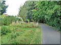
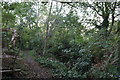
Path, Crane Park
A linear park running beside the River Crane.
Image: © Robin Webster
Taken: 14 Sep 2012
0.11 miles
8

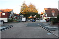
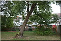
Small building, Crane Park
It is an Environment Agency site, with a mysterious warning of underwater obstructions, although externally there is no water visible within the compound. However, just across the path to the left is a modern sluice on the bypass channel for the former Fulwell Mill.
Image: © Robin Webster
Taken: 14 Sep 2012
0.12 miles
10
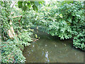
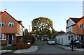
River Crane
This is an artificial cut, the bypass to the former Fulwell Mills (paper). The far bank is a long island with the natural river course (where the mills were) beyond. Both branches continue to take flow via weirs.
Image: © Robin Webster
Taken: 14 Sep 2012
0.12 miles