IMAGES TAKEN NEAR TO
Crossways, EGHAM, TW20 8EE
Introduction
This page details the photographs taken nearby to Crossways, TW20 8EE by members of the Geograph project.
The Geograph project started in 2005 with the aim of publishing, organising and preserving representative images for every square kilometre of Great Britain, Ireland and the Isle of Man.

There are currently over 7.5m images from over14,400 individuals and you can help contribute to the project by visiting https://www.geograph.org.uk
Image Map (Loading...)


Getting Data...Please wait
Leaflet Map data © OpenStreetMap
Images are licensed for reuse under creativecommons.org/licenses/by-sa/2.0
Notes
- Clicking on the map will re-center to the selected point.
- The higher the marker number, the further away the image location is from the centre of the postcode.
Image Listing (14 Images Found)
Images are licensed for reuse under creativecommons.org/licenses/by-sa/2.0
Image
Details
Distance
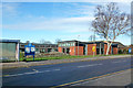
4
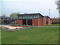
Hythe Centre
A new social centre / public hall on Thorpe Road.
Image: © David Squire
Taken: 21 Apr 2006
0.12 miles
5
The Hythe Centre
On Thorpe Road, opened in 2002.
Image: © Robin Webster
Taken: 17 Jan 2015
0.17 miles
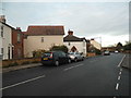
6
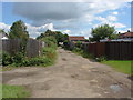
Devil's Lane, Egham Hythe
A view along Devil's Lane, an unmade access road that runs from Thorpe Lea Road to Huntingfield Way.
Image: © Alan Hunt
Taken: 5 Jul 2012
0.18 miles
7
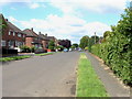
Huntingfield Way, Egham Hythe
A view along Huntingfield Way, a residential road in Egham Hythe, from the junction with Devil's Lane.
Image: © Alan Hunt
Taken: 5 Jul 2012
0.20 miles
8
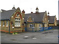
Egham Hythe: Hythe Primary School
Old Ordnance Survey maps show these buildings in the Edition of 1899, but not in the Edition of 1882. The building at the end beyond the close board fence appears to have been sold off for residential use. The School's website is here http://www.hythe.surrey.sch.uk/index.htm
Image: © Nigel Cox
Taken: 5 Aug 2008
0.20 miles
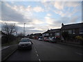
9
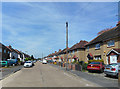
Hythe Field Avenue
This is Egham Hythe, a mid C20th suburb of Egham.
Image: © Des Blenkinsopp
Taken: 10 May 2017
0.22 miles
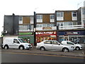
10
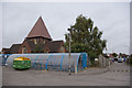
St Paul's Church, Egham Hythe
This view of the church was taken from the car park of The Magna Carta School.The bungalows in the background are in St Paul's Road
Image: © Rachel Keegan
Taken: 11 Oct 2009
0.23 miles