IMAGES TAKEN NEAR TO
Lacey Close, EGHAM, TW20 8DX
Introduction
This page details the photographs taken nearby to Lacey Close, TW20 8DX by members of the Geograph project.
The Geograph project started in 2005 with the aim of publishing, organising and preserving representative images for every square kilometre of Great Britain, Ireland and the Isle of Man.

There are currently over 7.5m images from over14,400 individuals and you can help contribute to the project by visiting https://www.geograph.org.uk
Image Map
Images are licensed for reuse under creativecommons.org/licenses/by-sa/2.0
Notes
- Clicking on the map will re-center to the selected point.
- The higher the marker number, the further away the image location is from the centre of the postcode.
Image Listing (10 Images Found)
Images are licensed for reuse under creativecommons.org/licenses/by-sa/2.0
Image
Details
Distance
1
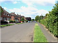
Huntingfield Way, Egham Hythe
A view along Huntingfield Way, a residential road in Egham Hythe, from the junction with Devil's Lane.
Image: © Alan Hunt
Taken: 5 Jul 2012
0.06 miles
2
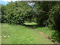
Footpath, Egham Hythe
The footpath that runs along the edge of the housing estate of Egham Hythe.
Image: © Alan Hunt
Taken: 5 Jul 2012
0.06 miles
3
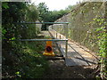
Walkway, Mead Lake
The disused walkway over the wet ground by Mead Lake. The sleepers are rotting away nicely and the attempt at rectifying the situation with the metal plates is no longer safe. The footpath has been diverted through the neighbouring field.
Image: © Alan Hunt
Taken: 5 Jul 2012
0.10 miles
4
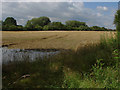
Field, Egham Hythe
A crop field on the floodplain of the River Thames. In the corner can be seen evidence of the wettest June since the last wettest June.
Image: © Alan Hunt
Taken: 5 Jul 2012
0.13 miles
5
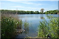
Mead Lake
Not named on the map but I'm guessing that's what it's called because the adjacent stream is the Mead Lake Ditch. An old gravel pit, probably. Now a fishing lake.
And what stream or lake anywhere near an urban area would be complete without a shopping trolley?
Image: © Des Blenkinsopp
Taken: 10 May 2017
0.16 miles
6
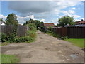
Devil's Lane, Egham Hythe
A view along Devil's Lane, an unmade access road that runs from Thorpe Lea Road to Huntingfield Way.
Image: © Alan Hunt
Taken: 5 Jul 2012
0.17 miles
7
Egham Hythe - Footpath towards Devil's Lane
Footpath bordering Thorpe Hay Meadow Nature Reserve an SSSI site.
Wikipedia : https://en.wikipedia.org/wiki/Thorpe_Hay_Meadow
Image: © James Emmans
Taken: 3 Jan 2017
0.21 miles
8
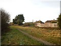
Thorpe Hay Meadow
The northern corner of the hay meadow, a small reserve owned by Surrey Wildlife Trust
Image: © Alan Hunt
Taken: 5 Jul 2012
0.23 miles
9
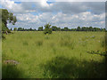
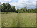
Thames floodplain
A large area of fallow ground on the Thames floodplain from the footpath through the Thorpe Hay Meadow. The Thames is about 700 metres away behind the trees in the distance.
Image: © Alan Hunt
Taken: 5 Jul 2012
0.23 miles
10
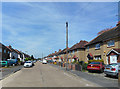
Hythe Field Avenue
This is Egham Hythe, a mid C20th suburb of Egham.
Image: © Des Blenkinsopp
Taken: 10 May 2017
0.24 miles