IMAGES TAKEN NEAR TO
Gleen Gardens, STAINES-UPON-THAMES, TW19 7FA
Introduction
This page details the photographs taken nearby to Gleen Gardens, TW19 7FA by members of the Geograph project.
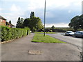
The Geograph project started in 2005 with the aim of publishing, organising and preserving representative images for every square kilometre of Great Britain, Ireland and the Isle of Man.

There are currently over 7.5m images from over14,400 individuals and you can help contribute to the project by visiting https://www.geograph.org.uk
Image Map
Images are licensed for reuse under creativecommons.org/licenses/by-sa/2.0
Notes
- Clicking on the map will re-center to the selected point.
- The higher the marker number, the further away the image location is from the centre of the postcode.
Image Listing (42 Images Found)
Images are licensed for reuse under creativecommons.org/licenses/by-sa/2.0
Image
Details
Distance
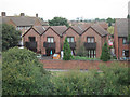
1
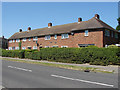
1960s housing, Stanwell
A block of four houses on Clare Road, Stanwell. This area between the original village and the A30 was developed in the 1960s.
Image: © Alan Hunt
Taken: 1 Aug 2013
0.05 miles
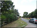
2
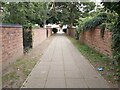
Footpath between Roads
A view of a cut through footpath between Town Lane and Diamedes Avenue in Stanwell in Surrey just east of the Staines Reservoirs.
Image: © John P Reeves
Taken: 13 Sep 2021
0.10 miles
3
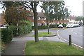
Clare Road, Stanwell
Near junction with Viscount Road, TW19. Taken very close to grid line according to 1:50,000 map, may be just over.....
Image: © Andrew Hill
Taken: 16 Jul 2008
0.11 miles
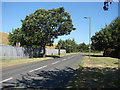
4
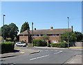
Clyde Road, Stanwell
The junction between Clyde Road and Clare Road. The houses date from the 1960s.
Image: © Alan Hunt
Taken: 1 Aug 2013
0.13 miles
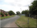
7
Town Lane, Stanwell
The road that skirts the eastern side of Stanwell with the Staines reservoir on the left.
Image: © Alan Hunt
Taken: 1 Aug 2013
0.14 miles
10
Houses near the Reservoir
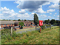
Not a spectacular view, but one that shows how high the reservoir banks are compared to their surroundings. This is at the eastern end of the 1+ km pathway across Staines Reservoir.
Image: © Des Blenkinsopp
Taken: 6 Jun 2019
0.14 miles