IMAGES TAKEN NEAR TO
Upper Halliford Road, SHEPPERTON, TW17 8SN
Introduction
This page details the photographs taken nearby to Upper Halliford Road, TW17 8SN by members of the Geograph project.
The Geograph project started in 2005 with the aim of publishing, organising and preserving representative images for every square kilometre of Great Britain, Ireland and the Isle of Man.

There are currently over 7.5m images from over14,400 individuals and you can help contribute to the project by visiting https://www.geograph.org.uk
Image Map
Images are licensed for reuse under creativecommons.org/licenses/by-sa/2.0
Notes
- Clicking on the map will re-center to the selected point.
- The higher the marker number, the further away the image location is from the centre of the postcode.
Image Listing (69 Images Found)
Images are licensed for reuse under creativecommons.org/licenses/by-sa/2.0
Image
Details
Distance
1
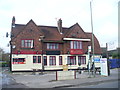
Last Post at The Bugle?
This old pub in Upper Halliford has closed again. Reading the sign, it has reopened as a Gentleman's Club, "The Blue Velvet".
It has undergone several name changes, including "The Tickled Trout" before reverting to "The Bugle".
Image: © Colin Smith
Taken: 14 Dec 2011
0.00 miles
2
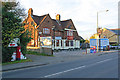
The Bugle Returns
At first glance an unusual name for a pub, but the explanation is that this was for many years called The Bugle, before being renamed firstly to The Tickled Trout, then Trawlers (see Image for a photo in that guise), before reverting to its previous name, hence The Bugle Returns. However, even The Bugle was not its original name - it started off in 1827 as The Black Horse, with the name The Bugle arriving by 1861.
For a close up of the postbox on the left, see Image
Image: © Ian Capper
Taken: 26 Nov 2010
0.00 miles
3
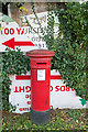
"Anonymous" postbox
Close up of the postbox in Image
The lack of royal cipher, hence the description "anonymous", is a particular feature of boxes dated between 1879 and 1887 manufactured by the firm Handyside during this period. The positioning of the aperture implies that this box dates from 1883 onwards, earlier ones having the aperture positioned higher up (e.g. see Image).
Image: © Ian Capper
Taken: 26 Nov 2010
0.02 miles
4
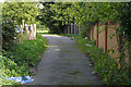
Footpath near Upper Halliford
The eastern end of the footpath from Charlton to the Upper Halliford Road. The Bugle Returnes public house is behind the fence on the left.
Image: © Alan Hunt
Taken: 24 Sep 2015
0.02 miles
5
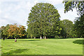
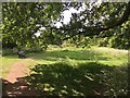
Beech clump, Upper Halliford Park
A beech clump in the recreation ground off Upper Halliford Road.
Image: © Alan Hunt
Taken: 24 Sep 2015
0.03 miles
6
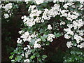
Hawthorn flowers and leaves, Halliford Park
See http://www.geograph.org.uk/photo/171628 for a general view of this park with a hawthorn tree in flower
Image: © David Hawgood
Taken: 17 May 2006
0.05 miles
7
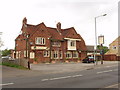
Trawlers, Upper Halliford
This public house has also been called "The Tickled Trout" and "The Bugle".
Image: © David Hawgood
Taken: 17 May 2006
0.05 miles
8
Hornbeam and Hawthorn, Halliford Park
Behind the hawthorn in flower is a group of large hornbeam trees. The park was the grounds of a large house, and there is a variety of trees including horse chestnut, apple and laburnum.
Image: © David Hawgood
Taken: 17 May 2006
0.05 miles
9
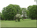
Halliford Park
Public park. Once to a very old house, turned over into nature again. The park has had some concrete brick rubble or other “hard core” deposited deep beneath some parts leading to its greater than natural undulations, which also adds to its already rather well-draining soil, meaning paths and grass has not been known to have been flooded.
Image: © Ad-lad
Taken: 8 May 2020
0.05 miles
10
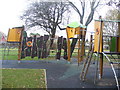
Child's Play, Upper Halliford
Children's playground by Upper Halliford Road, near Shepperton.
Image: © Colin Smith
Taken: 14 Dec 2011
0.05 miles