IMAGES TAKEN NEAR TO
Peregrine Road, SUNBURY-ON-THAMES, TW16 6JL
Introduction
This page details the photographs taken nearby to Peregrine Road, TW16 6JL by members of the Geograph project.
The Geograph project started in 2005 with the aim of publishing, organising and preserving representative images for every square kilometre of Great Britain, Ireland and the Isle of Man.

There are currently over 7.5m images from over14,400 individuals and you can help contribute to the project by visiting https://www.geograph.org.uk
Image Map
Images are licensed for reuse under creativecommons.org/licenses/by-sa/2.0
Notes
- Clicking on the map will re-center to the selected point.
- The higher the marker number, the further away the image location is from the centre of the postcode.
Image Listing (67 Images Found)
Images are licensed for reuse under creativecommons.org/licenses/by-sa/2.0
Image
Details
Distance
1
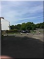
East access to Peregrine Road estate from Laytons Lane
A small green here is dwarfed by quite new hardstanding tucked away to the left
Image: © Ad-lad
Taken: 8 May 2020
0.06 miles
2
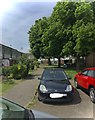
Part of Peregrine Road modern garden terraces
Housing in Lower Sunbury of a cheaper form for the quite affluent place, beautiful regardless of the smaller size than average.
Image: © Ad-lad
Taken: 8 May 2020
0.08 miles
3
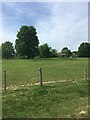
Laytons Lane from south end
From the residual horse fields which are Green Belt in Sunbury.
Image: © Ad-lad
Taken: 8 May 2020
0.11 miles
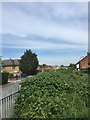
4
Narrow greenscape Sunbury borders
A fully green view can be had, with brevity of east-west truth, looking south from the west end of Nursery Road.
Image: © Ad-lad
Taken: 8 May 2020
0.12 miles
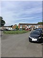
5
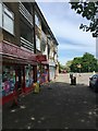
Peregrine Road groceries, salon, clothes cleaning (three shops)
This parade is supplemented by another about two hundred metres east. The other has a restaurant and pharmacy and similar grocery store among other outlets.
Image: © Ad-lad
Taken: 8 May 2020
0.12 miles
6
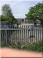
The way to Bishop Wand School
As viewed from public footpath (which runs through horse fields from near corner of Sunmead and Stratton Roads)
Image: © Ad-lad
Taken: 8 May 2020
0.14 miles
7
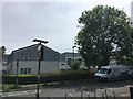
North east part of Peregrine Road
Relatively prettily designed apartments, some are socially rented and landscaping outlay is reasonable. Crossing the main road gives a short pleasant walk under the flyover bridge to Upper Halliford station. The zone is stubbornly outside of Zone 6 in transport.
Image: © Ad-lad
Taken: 8 May 2020
0.14 miles
8
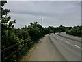
Ultra-Broad brief curve of Upper Halliford Road
This bizarrely brief (overall) dual carriageway section is relatively long compared to the minor junction (Nursery Road) it allegedly might help and from an era when large motor vehicles lacked anything like normal acceleration especially up the slope. Ripe for a retrenchment like the plans for a dualled Walton Bridge on the same road, it is unlikely the councils will agree funds and maintenance to restore trees that dominated the site. But some re-greening is currently the zeitgeist in national news and comparable boroughs (Waltham Forest) so Spelthorne may see what used to be which locally is clearly beautiful. It also pre-dates the motorway.
Image: © Ad-lad
Taken: 8 May 2020
0.14 miles
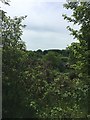
9
Horse field in Sunbury with one of them
Delightful horses dominate this field in each of its paddocks. A footpath of far more than 20 years public use runs through the field in space between most of the paddocks.
Image: © Ad-lad
Taken: 8 May 2020
0.14 miles
10
Spur cottages of Nursery Road
End wall of the 19th century terrace of simple architecture which is buffered from the new main course of the road by some gorse and other dry embankment adapted shrubs.
Image: © Ad-lad
Taken: 8 May 2020
0.15 miles