IMAGES TAKEN NEAR TO
Clifden Road, TWICKENHAM, TW1 4LS
Introduction
This page details the photographs taken nearby to Clifden Road, TW1 4LS by members of the Geograph project.
The Geograph project started in 2005 with the aim of publishing, organising and preserving representative images for every square kilometre of Great Britain, Ireland and the Isle of Man.

There are currently over 7.5m images from over14,400 individuals and you can help contribute to the project by visiting https://www.geograph.org.uk
Image Map
Images are licensed for reuse under creativecommons.org/licenses/by-sa/2.0
Notes
- Clicking on the map will re-center to the selected point.
- The higher the marker number, the further away the image location is from the centre of the postcode.
Image Listing (72 Images Found)
Images are licensed for reuse under creativecommons.org/licenses/by-sa/2.0
Image
Details
Distance
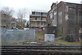
1
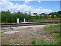
Railway lines near Twickenham
This view is from Station Road, just west of Twickenham station. The nearer lines carry trains on their way to and from Whitton as well as trains going to Strawberry Hill, whilst the line beyond with the maintenance train on it carries trains from Strawberry Hill which have crossed over the Whitton lines, just to the left of the photograph.
Image: © Marathon
Taken: 6 Jul 2011
0.09 miles
2

Railway signals west of Twickenham station
This view is from Station Road, just west of Twickenham station. The nearer lines carry trains on their way to and from Whitton as well as trains going to Strawberry Hill, whilst the line beyond carries trains from Strawberry Hill which have crossed over the Whitton lines.
Image: © Marathon
Taken: 6 Jul 2011
0.09 miles
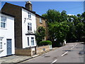
3
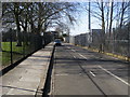
Station Road
Station Road Twickenham
Image: © Shaun Ferguson
Taken: 15 Feb 2013
0.10 miles
4
Railway lines near Twickenham
This view is from Station Road, just west of Twickenham station. The nearer lines carry trains on their way to and from Whitton as well as trains going to Strawberry Hill, whilst the line beyond carries trains from Strawberry Hill which have crossed over the Whitton lines, just to the left of the photograph.
Image: © Marathon
Taken: 6 Jul 2011
0.11 miles
5
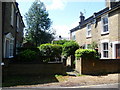
Cottages off Staten Gardens
This group of six cottages, facing across a passageway, are seen here from Staten Gardens.
Image: © Marathon
Taken: 6 Jul 2011
0.12 miles
6
The Old Bakery, Lion Road
On the corner where Lion Road turns into Staten Gardens, The Old Bakery is the very last cottage in this row, beyond the one with the brown door.
Image: © Marathon
Taken: 6 Jul 2011
0.12 miles
8
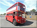
A Routemaster Bus in Station Road, Twickenham
This photo shows London Transport RM1941 (ALD 941B) parked in Station Road near The Albany Hotel being on special service 667 to Hampton Court via Fulwell and Hampton Hill. When that vehicle was delivered to LT in 1964, it was fitted with an illuminated advertisement panel on its offside, but as can be seen from the photo, that panel has long since been removed.
Image: © David Hillas
Taken: 23 Jul 2022
0.12 miles
9
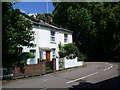
Houses in Lion Road
This is an attractive collection of houses and cottages, just before Lion Road turns the corner into Staten Gardens.
Image: © Marathon
Taken: 6 Jul 2011
0.13 miles
10
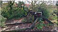
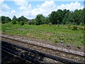
Twickenham Rough
Maintained by Richmond Council, this linear conservation site links Twickenham Station and Marsh Farm Lane, with a surfaced path running parallel to the River Crane and the railway.
In a nod to the site's former use as a railway siding, a set of buffers and a short stretch of track have been left as a feature.
Image: © Mark Percy
Taken: 17 Mar 2023
0.14 miles