IMAGES TAKEN NEAR TO
Bedfont Lane, FELTHAM, TW14 9NJ
Introduction
This page details the photographs taken nearby to Bedfont Lane, TW14 9NJ by members of the Geograph project.
The Geograph project started in 2005 with the aim of publishing, organising and preserving representative images for every square kilometre of Great Britain, Ireland and the Isle of Man.

There are currently over 7.5m images from over14,400 individuals and you can help contribute to the project by visiting https://www.geograph.org.uk
Image Map
Images are licensed for reuse under creativecommons.org/licenses/by-sa/2.0
Notes
- Clicking on the map will re-center to the selected point.
- The higher the marker number, the further away the image location is from the centre of the postcode.
Image Listing (16 Images Found)
Images are licensed for reuse under creativecommons.org/licenses/by-sa/2.0
Image
Details
Distance
2
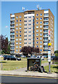
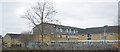
Housing Block, Bedfont Lane
The box of electrics in front looks in a state. I hope it's not important.
Image: © Des Blenkinsopp
Taken: 5 Jul 2017
0.08 miles
3
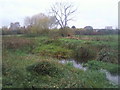
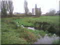
The Longford River at Bedfont Lane Recreation Ground
The Longford River was constructed in 1638 to take water from the River Colne. This would then supplement the water supply to Hampton Court and enable the development of the water features in the park. This view looks across the river from Glebelands Playing Fields to Bedfont Recreation Ground.
Image: © Marathon
Taken: 17 Nov 2010
0.13 miles
4
The Longford River near Feltham
The Longford River was constructed in 1638 to take water from the River Colne. This would then supplement the water supply to Hampton Court and enable the development of the water features in the park. Here it flows between Bedfont Lane Recreation Ground on the right and Glebelands Playing Fields on the left.
Image: © Marathon
Taken: 17 Nov 2010
0.15 miles
5
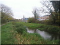
The Longford River north of Feltham station
The path alongside the Longford River here leads to Feltham station. The Longford River was constructed in 1638 to take water from the River Colne. This would then supplement the water supply to Hampton Court and enable the development of the water features in the park. The spire of the former St Catherine's Church near Feltham station can be seen over the trees.
Image: © Marathon
Taken: 17 Nov 2010
0.15 miles
7
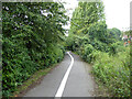
Path from Westmacott Drive to Bedfont Lane
Image: © Robin Webster
Taken: 12 Aug 2017
0.19 miles
8
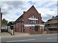
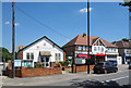
Calvary Free Grace Baptist Church
On Bedfont Lane.
Image: © Robin Webster
Taken: 12 Aug 2017
0.21 miles
9
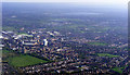
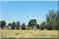
Feltham from the air
Feltham is close to Heathrow where the flight to Prague had just left the runway.
Image: © Thomas Nugent
Taken: 10 Apr 2011
0.21 miles