IMAGES TAKEN NEAR TO
Hounslow Road, FELTHAM, TW14 0BW
Introduction
This page details the photographs taken nearby to Hounslow Road, TW14 0BW by members of the Geograph project.
The Geograph project started in 2005 with the aim of publishing, organising and preserving representative images for every square kilometre of Great Britain, Ireland and the Isle of Man.

There are currently over 7.5m images from over14,400 individuals and you can help contribute to the project by visiting https://www.geograph.org.uk
Image Map
Images are licensed for reuse under creativecommons.org/licenses/by-sa/2.0
Notes
- Clicking on the map will re-center to the selected point.
- The higher the marker number, the further away the image location is from the centre of the postcode.
Image Listing (38 Images Found)
Images are licensed for reuse under creativecommons.org/licenses/by-sa/2.0
Image
Details
Distance
2
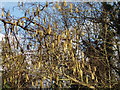
Catkins
These are on Hounslow Heath, by the River Crane near Baber Bridge.
Image: © David Hawgood
Taken: 20 Jan 2006
0.08 miles
3
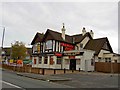
The Firework **ctory on Staines Road
An alternative use for a public house.
Image: © Steve Fareham
Taken: 21 Nov 2009
0.09 miles
4
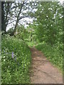
The London LOOP approaches Baber Bridge
The London LOOP follows the River Crane for some considerable distance from Hounslow Heath to the Grand Union Canal at Southall. This is approaching Baber Bridge which carries Staines Road over the river.
Image: © Marathon
Taken: 20 Apr 2011
0.09 miles
5
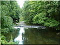
Weir on River Crane
There was formerly a mill pond more or less above this point when mills downstream were operating.
Image: © Robin Webster
Taken: 14 Sep 2012
0.09 miles
6
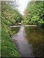
River Crane, Hounslow
Looking north towards Baber Bridge. This is the north west corner of the present extent of Hounslow Heath.
Image: © David Hawgood
Taken: 20 Jan 2006
0.10 miles
7
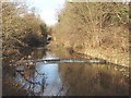
River Crane near Baber Bridge
The London LOOP follows the River Crane for some considerable distance from Hounslow Heath to the Grand Union Canal at Southall. This is looking upriver and approaching Baber Bridge which carries Staines Road over the river
Image: © Marathon
Taken: 20 Apr 2011
0.11 miles
8
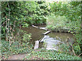
The River Crane divides
The upstream end of a long island. The near route formerly powered a snuff mill. The far route, the natural course used by parish boundaries, bypassed the mill via weirs.
Image: © Robin Webster
Taken: 14 Sep 2012
0.11 miles
10
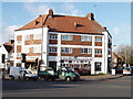
Shops near Baber Bridge, Hounslow
At the junction of Staines Road and River Gardens. The shops include an employment agency.
Image: © David Hawgood
Taken: 20 Jan 2006
0.11 miles