IMAGES TAKEN NEAR TO
Watermill Way, FELTHAM, TW13 5NQ
Introduction
This page details the photographs taken nearby to Watermill Way, TW13 5NQ by members of the Geograph project.
The Geograph project started in 2005 with the aim of publishing, organising and preserving representative images for every square kilometre of Great Britain, Ireland and the Isle of Man.

There are currently over 7.5m images from over14,400 individuals and you can help contribute to the project by visiting https://www.geograph.org.uk
Image Map
Images are licensed for reuse under creativecommons.org/licenses/by-sa/2.0
Notes
- Clicking on the map will re-center to the selected point.
- The higher the marker number, the further away the image location is from the centre of the postcode.
Image Listing (56 Images Found)
Images are licensed for reuse under creativecommons.org/licenses/by-sa/2.0
Image
Details
Distance
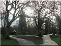
1
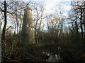
The Shot Tower at Crane Park Island
Now a visitor centre for the London Wildlife Trust, the tower was built in 1826 and was used to make hard shot, for ammunition in the making of weapons.
Image: © Peter S
Taken: 29 Dec 2015
0.08 miles
2
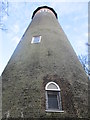
The Shot Tower at Crane Park Island
The tower is 83 feet high and is a Grade II listed building.
Image: © Peter S
Taken: 29 Dec 2015
0.08 miles
3
Crane park
This picture was taken in the summer.
Image: © Mr M Looker
Taken: 18 Jun 2008
0.08 miles
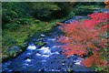
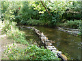
4

Tree reflections in the River Crane
A look downstream from the eastern tip of the island. Rocks placed in the river have been designed to speed up and slow down the flow of water at different points. The purpose of this arrangement is to create a better environment for breeding fish.
Image: © Peter S
Taken: 29 Dec 2015
0.09 miles
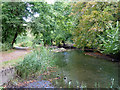
5
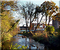
River Crane, Crane Park Island
The south side of Crane Park Island nature reserve, the edge of Crane Park and a London borough boundary, Richmond on the left, Hounslow on the right.
Image: © Des Blenkinsopp
Taken: 13 Nov 2011
0.09 miles
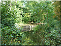
6
River Crane
A natural looking section within a wilder part of Crane Park, except for the flow deflectors, made of hurdles and stones. They are to produce varied flow speeds for the benefit of river wildlife.
Image: © Robin Webster
Taken: 14 Sep 2012
0.09 miles
7

Rocks in The Crane
These have been put in the river at intervals along its section through Crane Park.
http://www.hounslow.info/parks/cranevalley/TheRiver.htm
Image: © Des Blenkinsopp
Taken: 13 Nov 2011
0.09 miles
8
River Crane
Just downstream of the remains of Hounslow Powder Mills.
Image: © Robin Webster
Taken: 14 Sep 2012
0.10 miles
9
Crane Park Island ? near the entrance
This nature reserve has been described by Sir David Attenborough as “one of Richmond Borough’s best-kept secrets".
Image: © Peter S
Taken: 29 Dec 2015
0.10 miles
10
Crane Park at the powder mills site
This is the mill race downstream of where one of the lower powder mills was. The Hounslow Powder Mills had a complex layout of mills and associated waterways. Not all of the waterways are still present, but this one seems to have been associated with a mill at the camera position, and also with a mill which discharged through a channel just behind the large trees. This second channel has been filled in.
Image: © Robin Webster
Taken: 14 Sep 2012
0.11 miles