IMAGES TAKEN NEAR TO
Victors Drive, HAMPTON, TW12 3PJ
Introduction
This page details the photographs taken nearby to Victors Drive, TW12 3PJ by members of the Geograph project.
The Geograph project started in 2005 with the aim of publishing, organising and preserving representative images for every square kilometre of Great Britain, Ireland and the Isle of Man.

There are currently over 7.5m images from over14,400 individuals and you can help contribute to the project by visiting https://www.geograph.org.uk
Image Map
Images are licensed for reuse under creativecommons.org/licenses/by-sa/2.0
Notes
- Clicking on the map will re-center to the selected point.
- The higher the marker number, the further away the image location is from the centre of the postcode.
Image Listing (14 Images Found)
Images are licensed for reuse under creativecommons.org/licenses/by-sa/2.0
Image
Details
Distance
1
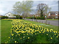
Daffodils alongside Oak Avenue
This small green is alongside Oak Avenue, here on the right with Maple Close across the road. Rain threatened on this March afternoon and the day soon deteriorated into a thoroughly wet and miserable one - see http://www.geograph.org.uk/photo/3903298 taken an hour later.
Image: © Marathon
Taken: 26 Mar 2014
0.06 miles
2
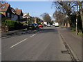
Oak Avenue
Oak Avenue passing Courtlands Avenue
Image: © Shaun Ferguson
Taken: 15 Feb 2013
0.12 miles
3
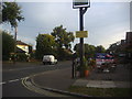
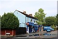
Corner of South Road and Oak Avenue, Hampton
The Royal Oak pub is on the right.
Image: © David Howard
Taken: 24 Oct 2011
0.12 miles
5
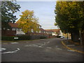
Fearnley Crescent at Oak Avenue mini roundabout, Hampton
Image: © David Howard
Taken: 24 Oct 2011
0.14 miles
6
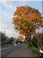
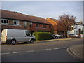
Oak Avenue, Hampton
There are some fine old trees here - oaks which date back to days well before the area was developed as a residential suburb.
Image: © Stefan Czapski
Taken: 1 Dec 2013
0.16 miles
7
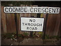
Road name and pre-Worboys sign
The borough of Richmond has kept a good number of these old no through roads and they still do a perfectly good job.
Image: © David Howard
Taken: 6 Dec 2010
0.19 miles
8
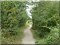
Public footpath towards Hanworth
This skirts a former reservoir on the left.
Image: © Robin Webster
Taken: 16 Sep 2012
0.21 miles
10
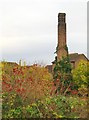
Autumn in Hanworth
From the end of Forge Lane, by St Richard's church, I followed a footpath through scrub, coming out in a little open area - much of it occupied by a grassy mound. According to the map, both scrub and grassland are part of a nature reserve - though I saw no name-board. Just south of the mound is a tall chimney, partly covered in ivy.
The chimney is clearly a relic of some former land-use, not in any way attached to the building just beyond, which is a house in a modern development. The name 'Forge Lane' might give a clue, but looking at a 1974 OS map, I see that in those days the area was occupied by commercial green-houses - so my guess is that the chimney had to do with a horticultural heating system.
In the foreground is evidence of the heavy crop of rose-hips in November 2012.
Image: © Stefan Czapski
Taken: 3 Nov 2012
0.23 miles