IMAGES TAKEN NEAR TO
Buckingham Road, HAMPTON, TW12 3LQ
Introduction
This page details the photographs taken nearby to Buckingham Road, TW12 3LQ by members of the Geograph project.
The Geograph project started in 2005 with the aim of publishing, organising and preserving representative images for every square kilometre of Great Britain, Ireland and the Isle of Man.

There are currently over 7.5m images from over14,400 individuals and you can help contribute to the project by visiting https://www.geograph.org.uk
Image Map
Images are licensed for reuse under creativecommons.org/licenses/by-sa/2.0
Notes
- Clicking on the map will re-center to the selected point.
- The higher the marker number, the further away the image location is from the centre of the postcode.
Image Listing (7 Images Found)
Images are licensed for reuse under creativecommons.org/licenses/by-sa/2.0
Image
Details
Distance
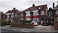
1
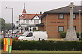
Swan house and the Swan pub
These are in Green lane in Hanworth
Image: © steve
Taken: 25 Jun 2005
0.05 miles
2
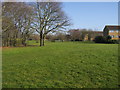
Hampton Common
Hampton Common off Oak Avenue
Image: © Shaun Ferguson
Taken: 15 Feb 2013
0.19 miles
3
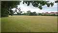
Hampton Common
Public open space on the western edge of Hampton, bordering Hanworth.
Houses on Buckingham Road can be seen to the right.
Image: © Jonathan Billinger
Taken: 5 Jul 2015
0.22 miles
5
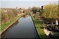
Longford River viewed from Stourton Avenue road bridge
Image: © Ken Clarke
Taken: 18 Mar 2009
0.23 miles
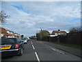
6
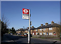
Hanworth Road, Hampton
Am I imagining it or have bus stops got a lot smarter in recent years.
Image: © Des Blenkinsopp
Taken: 8 Feb 2011
0.24 miles