IMAGES TAKEN NEAR TO
Birchwood Grove, HAMPTON, TW12 3DU
Introduction
This page details the photographs taken nearby to Birchwood Grove, TW12 3DU by members of the Geograph project.
The Geograph project started in 2005 with the aim of publishing, organising and preserving representative images for every square kilometre of Great Britain, Ireland and the Isle of Man.

There are currently over 7.5m images from over14,400 individuals and you can help contribute to the project by visiting https://www.geograph.org.uk
Image Map
Images are licensed for reuse under creativecommons.org/licenses/by-sa/2.0
Notes
- Clicking on the map will re-center to the selected point.
- The higher the marker number, the further away the image location is from the centre of the postcode.
Image Listing (19 Images Found)
Images are licensed for reuse under creativecommons.org/licenses/by-sa/2.0
Image
Details
Distance
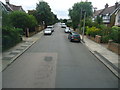
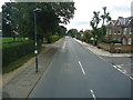
2
Looking along Broad Lane, Hampton
On this thoroughly wet and miserable afternoon, this view looks along busy Broad Lane past the crossroads with Nightingale Road to the left and Wensleydale Road to the right.
Image: © Marathon
Taken: 26 Mar 2014
0.15 miles
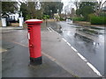
3
Wensleydale Road
Wensleydale Road junction with Broad Street
Image: © Shaun Ferguson
Taken: 15 Feb 2013
0.16 miles
4
Looking across Broad Lane, Hampton
On this thoroughly wet and miserable afternoon, this view looks across busy Broad Lane from the corner of Nightingale Road to Wensleydale Road.
Image: © Marathon
Taken: 26 Mar 2014
0.16 miles
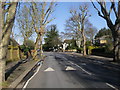
6
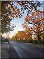
Hanworth Road, Hampton, in December
Looking north-west from the corner of Holles Close. On the right is the site occupied by the Lady Eleanor Holles School and Hampton School. Some fine old oaks survive here - relics of a more rural landscape. On the first day of December 2013 they had yet to lose their leaves.
Image: © Stefan Czapski
Taken: 1 Dec 2013
0.17 miles
7
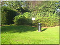
Where it all began!
This cannon embedded in the ground in Roy Grove marks the south eastern end of General Roy's original base line for setting out the Ordnance Survey triangulation of Great Britain in 1784. The white plaque in the background was put in place in 1926 to mark the 200th anniversary of General Roy's birth. The north western end of the base line is at Heathrow, on the other side of what was at the time Hounslow Heath Image
Image: © Rod Allday
Taken: 15 Oct 2011
0.17 miles
8
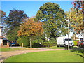
Roy Grove Hampton
In the centre of the photo is the cannon marking the south eastern end of the original OS base line Image
Image: © Rod Allday
Taken: 15 Oct 2011
0.18 miles
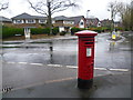
10
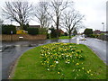
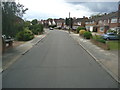
Traffic island where Buckingham Road meets Acacia Road
On a thoroughly wet and miserable afternoon, this view looks across a daffodil covered traffic island up Buckingham Road where it meets Acacia Road.
Image: © Marathon
Taken: 26 Mar 2014
0.19 miles