IMAGES TAKEN NEAR TO
Jeffs Close, HAMPTON, TW12 3AF
Introduction
This page details the photographs taken nearby to Jeffs Close, TW12 3AF by members of the Geograph project.
The Geograph project started in 2005 with the aim of publishing, organising and preserving representative images for every square kilometre of Great Britain, Ireland and the Isle of Man.

There are currently over 7.5m images from over14,400 individuals and you can help contribute to the project by visiting https://www.geograph.org.uk
Image Map
Images are licensed for reuse under creativecommons.org/licenses/by-sa/2.0
Notes
- Clicking on the map will re-center to the selected point.
- The higher the marker number, the further away the image location is from the centre of the postcode.
Image Listing (65 Images Found)
Images are licensed for reuse under creativecommons.org/licenses/by-sa/2.0
Image
Details
Distance
1
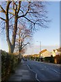
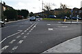
Uxbridge Road, Hampton (1)
View NNW from near the junction with Hanworth Road.
The name itself is interesting - this was the main road to Uxbridge in days when west Middlesex was still largely rural - and Uxbridge the next place of any consequence as you headed north-west. These days much of the intervening terrain is residential suburbs, and a stretch of the old road that crossed the Heathrow site (at its eastern end) has disappeared.
Image: © Stefan Czapski
Taken: 1 Dec 2013
0.03 miles
2

The Garth, Hampton
Modern 1960s style town houses
Image: © David Howard
Taken: 29 Jun 2014
0.04 miles
3
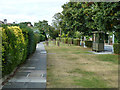
Wide verge, Uxbridge Road
A multitude of wooden posts have been placed lest any vehicle ventures onto the verge via the crossing driveways.
Image: © Robin Webster
Taken: 16 Sep 2012
0.04 miles
5
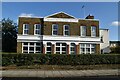
Former Jolly Gardeners pub, Uxbridge Road
Now apparently flats, the building still displays 'Isleworth Fine Ales' on its pediment.
Image: © Robin Webster
Taken: 16 Sep 2012
0.05 miles
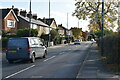
6
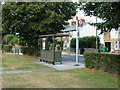
Hanworth Road bus stop, on Uxbridge Road
For buses towards Feltham. The only service appears to be route 285.
Image: © Robin Webster
Taken: 16 Sep 2012
0.05 miles
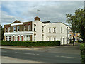
8
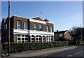
The Jolly Gardeners
This former pub in Uxbridge Road was no doubt named to recognize the large numbers of nurserymen and growers who worked this area in Victorian and early 20th C. times when it was an important provider of fresh products to London markets.
I wonder if Isleworth Ales were fine. We shall never know. Last brewed in 1924.
A short Brewery history on http://www.aim25.ac.uk/cgi-bin/vcdf/detail?coll_id=13366&inst_id=118&nv1=search&nv2=
Image: © Des Blenkinsopp
Taken: 8 Feb 2011
0.07 miles
10
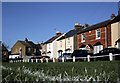
School Road Avenue
Victorian terraced housing typical of this part of Hampton Hill pictured from the corner of the football pitch in the small park opposite.
Image: © Des Blenkinsopp
Taken: 8 Feb 2011
0.09 miles