IMAGES TAKEN NEAR TO
Station Road, HAMPTON, TW12 2BN
Introduction
This page details the photographs taken nearby to Station Road, TW12 2BN by members of the Geograph project.
The Geograph project started in 2005 with the aim of publishing, organising and preserving representative images for every square kilometre of Great Britain, Ireland and the Isle of Man.

There are currently over 7.5m images from over14,400 individuals and you can help contribute to the project by visiting https://www.geograph.org.uk
Image Map
Images are licensed for reuse under creativecommons.org/licenses/by-sa/2.0
Notes
- Clicking on the map will re-center to the selected point.
- The higher the marker number, the further away the image location is from the centre of the postcode.
Image Listing (223 Images Found)
Images are licensed for reuse under creativecommons.org/licenses/by-sa/2.0
Image
Details
Distance
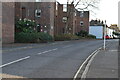
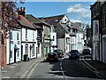
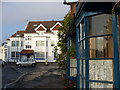
2
The Limes, Station Road, Hampton
A Georgian house of rather massive proportions - seen on a bright December afternoon.
Image: © Stefan Czapski
Taken: 8 Dec 2013
0.03 miles
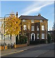
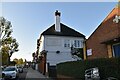
3
Hampton Maternity & Child Clinic
Grade II listed. https://historicengland.org.uk/listing/the-list/list-entry/1262051
Image: © N Chadwick
Taken: 7 Nov 2019
0.03 miles
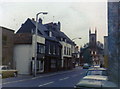
4
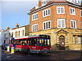
Station Road
Central Hampton at the corner of Station Road and High Street. The bus to Kingston is passing Millennium House, a former Barclays Bank.
Image: © Colin Smith
Taken: 21 Dec 2007
0.03 miles
5
Upper Sunbury Road, Hampton
The A308 runs between Kensington, in London, and Bisham in Berkshire, staying no more than 3 miles from the River Thames http://en.wikipedia.org/wiki/A308_road . It is very narrow and winding as it passes through Hampton village as Upper Subury Road and, briefly, Thames Street. This section often suffers from traffic congestion.
The ornate building with the tower is part of the Southwark & Vauxhall Water Company's Works.
Image: © David Dixon
Taken: 11 Apr 2015
0.03 miles

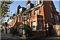
8
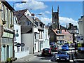
Hampton Village and St Mary's Church Tower
The A308 runs between Kensington, in London, and Bisham in Berkshire, staying no more than 3 miles from the River Thames http://en.wikipedia.org/wiki/A308_road . It is very narrow and winding as it passes through Hampton village as Upper Subury Road and, briefly, Thames Street. This section often suffers from traffic congestion.
Image: © David Dixon
Taken: 11 Apr 2015
0.04 miles
9
Station Road, Hampton in 1974
Looking south east down Station Road towards the Red Lion pub, with the then ubiquitous tacky plastic red barrel above its sign. The High Street crosses the end of this road at a slight angle.
Image: © Stephen Williams
Taken: Unknown
0.04 miles
10
Thames Street, Hampton
Looking westwards towards the junction with High Street. The bay windows on the right belong to former cottages, now offices.
Image: © Colin Smith
Taken: 21 Dec 2007
0.05 miles