IMAGES TAKEN NEAR TO
St. James's Avenue, HAMPTON, TW12 1HN
Introduction
This page details the photographs taken nearby to St. James's Avenue, TW12 1HN by members of the Geograph project.
The Geograph project started in 2005 with the aim of publishing, organising and preserving representative images for every square kilometre of Great Britain, Ireland and the Isle of Man.

There are currently over 7.5m images from over14,400 individuals and you can help contribute to the project by visiting https://www.geograph.org.uk
Image Map
Images are licensed for reuse under creativecommons.org/licenses/by-sa/2.0
Notes
- Clicking on the map will re-center to the selected point.
- The higher the marker number, the further away the image location is from the centre of the postcode.
Image Listing (90 Images Found)
Images are licensed for reuse under creativecommons.org/licenses/by-sa/2.0
Image
Details
Distance
1
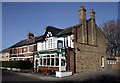
The Windmill
In Windmill Road.
There was a windmill opposite here in Victorian times, on the bank of the Longford river. There is a picture of it in the bar, along with other historic views of old Hampton Hill.
There are some fine decorative glass windows in the two entrances, reputedly saved from brewery vandalism in the 1960's by a previous landlord who hid them in his garden shed.
Image: © Des Blenkinsopp
Taken: 8 Feb 2011
0.07 miles

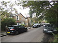
3
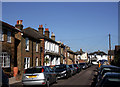
Wolsey Road, Hampton Hill
Of course, there were no cars about when these little roads were built.
There certainly are now ....
This road is presumably named after Cardinal Wolsey of nearby Hampton Court.
Image: © Des Blenkinsopp
Taken: 8 Feb 2011
0.09 miles
4
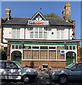
The Windmill Pub Hampton Hill, September 2019
The sadly now shut Windmill Pub in Hampton Hill.
Image: © Jude
Taken: 19 Sep 2019
0.09 miles
5

The railway line by Eastbank Road, Hampton Hill
Image: © David Howard
Taken: 29 Jun 2014
0.10 miles
6
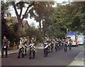
ATC Band, St. James' Road, Hampton, 1971
This is the band of No. 267 Squadron, Air Training Corps leading a parade along Saint James' Road, Hampton Hill in 1971. I cannot remember the exact event. The Officer on the left is Gordon Tims.
Image: © Stephen Williams
Taken: Unknown
0.11 miles
7

The Longford River, by Windmill Road
Looking downstream from the footbridge at the junction of the Uxbridge Road and Windmill Road. This stretch of the Longford River flows parallel to Windmill Road (which can be seen through the railings on the left).
The Longford was one of a number of artificial water-courses - so-called 'rivers' - constructed in the London and Middlesex areas in the 17th century for purposes of water supply rather than navigation. See also: Image
Image: © Stefan Czapski
Taken: 28 Sep 2012
0.12 miles
8
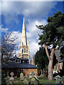
St James's Church
View from the churchyard with new parish hall in the foreground. When I was a kid you could climb up a rickety ladder inside the spire as far as the first row of little windows in the spire. Bet you can't in these Healthy and Safe days.
Image: © Des Blenkinsopp
Taken: 7 Apr 2004
0.12 miles
10
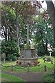
St James, St James Road, Hampton Hill - War Memorial
Image: © John Salmon
Taken: 13 Jul 2011
0.12 miles