IMAGES TAKEN NEAR TO
Rectory Grove, HAMPTON, TW12 1AH
Introduction
This page details the photographs taken nearby to Rectory Grove, TW12 1AH by members of the Geograph project.
The Geograph project started in 2005 with the aim of publishing, organising and preserving representative images for every square kilometre of Great Britain, Ireland and the Isle of Man.

There are currently over 7.5m images from over14,400 individuals and you can help contribute to the project by visiting https://www.geograph.org.uk
Image Map
Images are licensed for reuse under creativecommons.org/licenses/by-sa/2.0
Notes
- Clicking on the map will re-center to the selected point.
- The higher the marker number, the further away the image location is from the centre of the postcode.
Image Listing (14 Images Found)
Images are licensed for reuse under creativecommons.org/licenses/by-sa/2.0
Image
Details
Distance
1
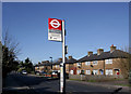
Hanworth Road, Hampton
Am I imagining it or have bus stops got a lot smarter in recent years.
Image: © Des Blenkinsopp
Taken: 8 Feb 2011
0.01 miles
2
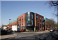
New Block, Dean Road
On the site of a former small row of shop houses.
Image: © Des Blenkinsopp
Taken: 8 Feb 2011
0.08 miles
4

Hampton Academy
One of a line of three big schools along Hanworth Road, Hampton Academy is, according to the sign, a learning school.
Sounds a novel idea, doesn't it ....
Image: © Des Blenkinsopp
Taken: 8 Feb 2011
0.14 miles
5
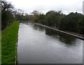
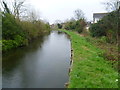
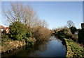
The Longford River
Charles I ordered the construction of the totally artificial watercourse known as the Longford River to carry water from the River Colne to the water features in Bushy Park and then on to the Long Water in Home Park at Hampton Court. The Longford River opened in 1638.
Much of the Longford River between the A316 and Bushy Park is inaccessible and it can only be glimpsed from bridges. This view is from a footbridge linking Dean Road with Longford Close.
Image: © Marathon
Taken: 26 Mar 2014
0.15 miles
6
The Longford River
Charles I ordered the construction of the totally artificial watercourse known as the Longford River to carry water from the River Colne to the water features in Bushy Park and then on to the Long Water in Home Park at Hampton Court. The Longford River opened in 1638.
Much of the Longford River between the A316 and Bushy Park is inaccessible and it can only be glimpsed from bridges. This view is from a footbridge linking Dean Road with Longford Close.
Image: © Marathon
Taken: 26 Mar 2014
0.19 miles
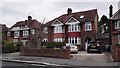
7
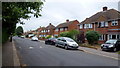
Buckingham Road, Hampton
1950's semi-detached suburbia.
Image: © Jonathan Billinger
Taken: 5 Jul 2015
0.19 miles
8
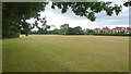
Hampton Common
Public open space on the western edge of Hampton, bordering Hanworth.
Houses on Buckingham Road can be seen to the right.
Image: © Jonathan Billinger
Taken: 5 Jul 2015
0.19 miles
9
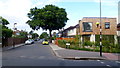
New-build on a corner plot
Someone's garden has made way for a modern box on the corner of dean Road and Buckingham Road, Hampton.
Image: © Jonathan Billinger
Taken: 5 Jul 2015
0.19 miles
10
Longford River from Dean Road Footbridge
That this is an artificial watercourse is shown here, where it is flowing along a slight embankment above surrounding ground level.
I think this might be the same place as Image which has a less precise given location.
Image: © Des Blenkinsopp
Taken: 8 Feb 2011
0.21 miles