IMAGES TAKEN NEAR TO
Ailsa Road, TWICKENHAM, TW1 1QJ
Introduction
This page details the photographs taken nearby to Ailsa Road, TW1 1QJ by members of the Geograph project.
The Geograph project started in 2005 with the aim of publishing, organising and preserving representative images for every square kilometre of Great Britain, Ireland and the Isle of Man.

There are currently over 7.5m images from over14,400 individuals and you can help contribute to the project by visiting https://www.geograph.org.uk
Image Map
Images are licensed for reuse under creativecommons.org/licenses/by-sa/2.0
Notes
- Clicking on the map will re-center to the selected point.
- The higher the marker number, the further away the image location is from the centre of the postcode.
Image Listing (79 Images Found)
Images are licensed for reuse under creativecommons.org/licenses/by-sa/2.0
Image
Details
Distance
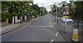
1
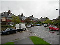
St Margaret's Drive, Twickenham
At the junction of Ailsa Road
Image: © Danny P Robinson
Taken: 22 Oct 2006
0.09 miles
2
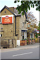
Ailsa Tavern, St Margarets
The Ailsa Tavern is a Shepherd Neame pub on St Margarets Road by the junction with St Margarets Drive.
Image: © Stephen McKay
Taken: 26 Apr 2017
0.10 miles
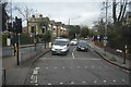
3
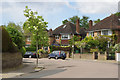
Ailsa Road, St Margarets
This is an area of substantial houses in leafy streets, a short walk from the Thames and St Margarets station. The name derives from the Marquess of Ailsa, a title once held by the owner of St Margarets House.
Image: © Stephen McKay
Taken: 26 Apr 2017
0.10 miles
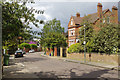
4
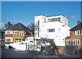
Art Deco House, Ailsa Road, Twickenham
Set in a street of conventional housing from the same period, one house went for the full 1930s thing without worrying about the neighbours.
Image: © Des Blenkinsopp
Taken: 8 Jan 2019
0.12 miles
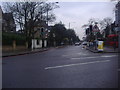
6
St George's Road, St Margarets
A street of substantial villas in a variety of styles.
Image: © Stephen McKay
Taken: 26 Apr 2017
0.12 miles
8
St Margarets Road
From A316 roundabout Twickenham
Image: © David Howard
Taken: 21 Feb 2011
0.15 miles
10
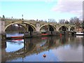
Richmond Half Tide Lock
Richmond's Half Tide Lock opened in 1894. For two hours after the passage of the tide the sluice gates underneath are lowered to block the river. This maintains the water level at a height which enables navigation up to Teddington Lock three miles upstream.
This provided navigable water all hours of the day and meant a yacht club, based on the reach, could be sustained
Image: © Mark Percy
Taken: 4 Dec 2005
0.15 miles